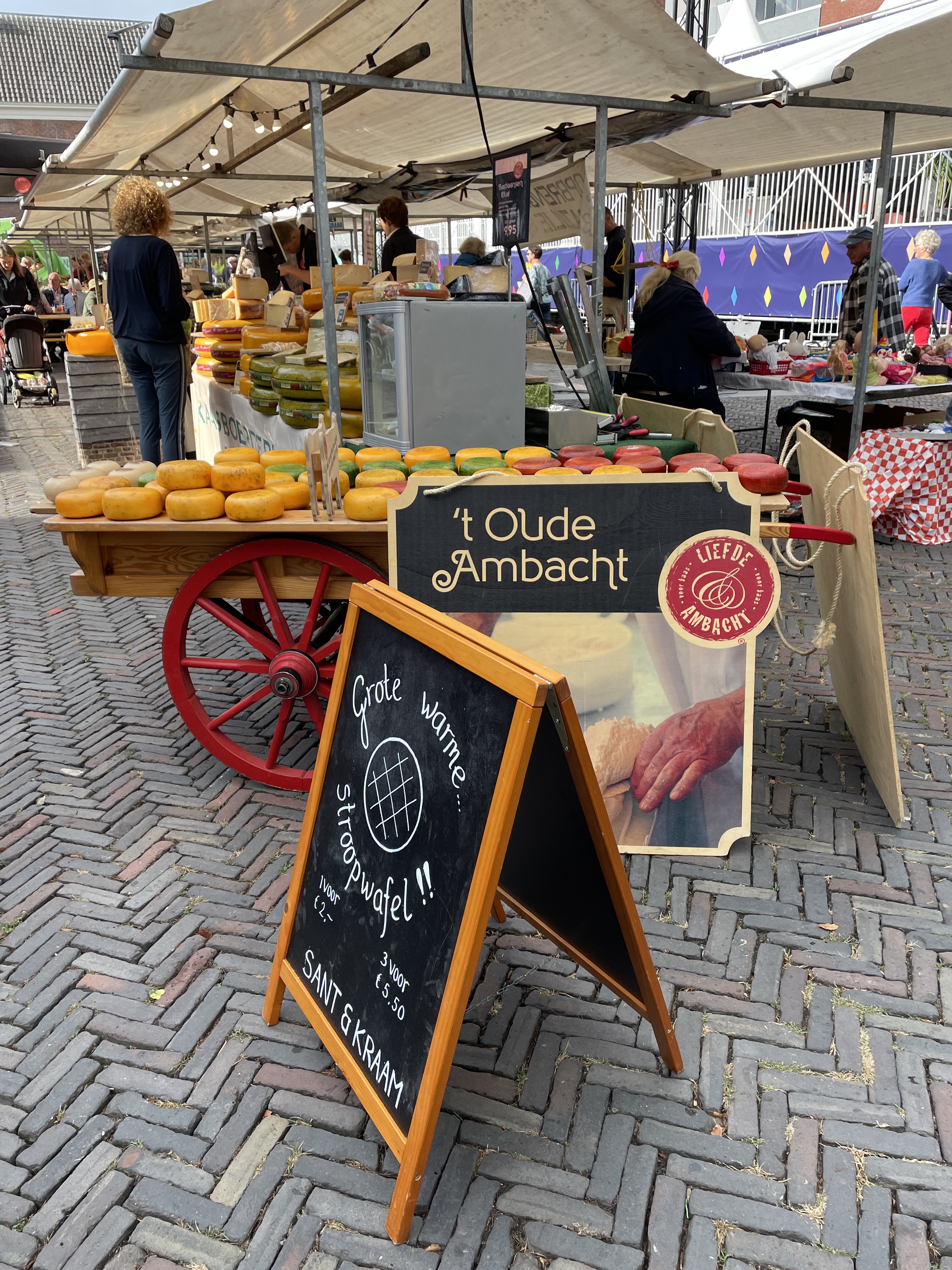
A few weeks ago a friend of mine visited the cheese market in the quaint little town Woerden, and I said to myself, ‘ek wil ook soontoe gaan!’ (I do speak Afrikaans when I speak to myself). So I did, and though it was not the big annual cheese festival, the weekly ‘Boerenmark’ (farmer’s market) also was a delight, with plenty to see, eat, learn and photograph.
Driving in the beautiful rural farmland area around Woerden, was both relaxing and highly disturbing.
An international distress signal is to hoist your country’s flag upside down. The Dutch flag has three horisontal colours, with red on top. The Dutch Government recently announced they need to lower nitrogen emissions from the livestock by cutting back on farming activities and this led to widespread protest actions.
‘Dutch government proposals for tackling nitrogen emissions indicate a radical cut in livestock – they estimate 11,200 farms will have to close and another 17,600 farmers will have to significantly reduce their livestock. Other proposals include a reduction in intensive farming and the conversion to sustainable green farms. As such, the relocation or buyout of farmers is almost inevitable, but forced buyouts are a scenario many hope to avoid.’ (BBC News 29 July).
Traveling in The Netherlands nowadays the scene is marked by upside down distress call flags and messages against the planned government action.
From Woerden I drove to Oudshoorn, because my mom Susan lives in Baron van Reedestraat in Oudtshoorn. Though Oudshoorn was a town, it is now amalgamated into Alphen aan den Rijn (1918) and there’s actually very little reference to Oudshoorn. Oudtshoorn (the one with the t after the d is the town in South Africa) is named after Baron Pieter van Reede van Oudshoorn (which is the town, that’s not a town anymore, in The Netherlands). Pieter was born in Utrecht (in The Netherlands, not the neighbouring town to my town of birth Dundee in Northern Natal, South Africa, not Brazil – wow, these colonial names make accurate story telling cumbersome) in 1714. He was ‘Heer’ or Baron of Oudshoorn, Ridderbuurt and Gnephoek. Those are all now little suburbs of Alphen aan den Rijn. Baron van Reede was appointed the Governor of Die Kaapkolonie in 1772, but he died at sea on his way to fill his post in SA and never was the sitting governor of the Cape.
In Oudshoorn, van Schaik is the go-to guy for authentic delicious ‘stroopwafels’ and not the bookstore where I bought my university handbooks.
I didn’t see any ostriches.
I ended my daytrip with a stroll on the beach, where many German bunkers, which form part of the Atlantic Wall, are still visible.
The Netherlands is a stunning travel destination, and the links to South Africa is a real pleasure to explore.
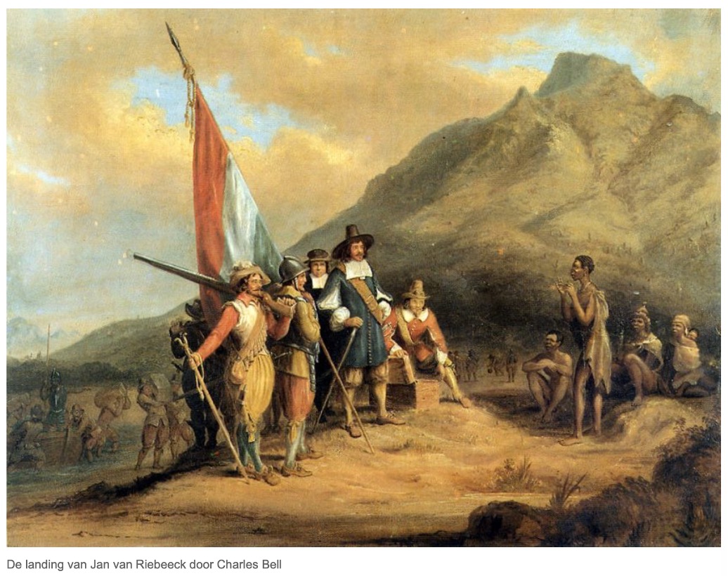
It’s commonly known that on 6 April 1652, Jan van Riebeeck landed at the Cape of Good Hope, or if you’re thát kind of person, aka the Cape of Storms. Johan Anthoniszoon ‘Jan’ van Riebeeck was a Dutch navigator and colonial administrator in service of the Dutch East India Company, the VOC.
It’s probably not that commonly known that now for a few days a week I stay in Delft, in the Netherlands. Other than the strolling through the town, enjoying the architecture, the canals, dodging the cyclists and frequenting much too frequently the many street cafes who gladly serve a wide variety of Dutch, Belgian and French beers, the mere reality of the South African historic links to this part of the world provides me with a lot of pleasure.
I received my bachelor’s degree in 1987 from the University of the Orange Free State. (This irrelevant fact becomes relevant later on, keep reading). Nowadays it’s just the Free State, the Orange have faded away in the post-modern South Africa. The Boer Trekkers, (Voortrekkers), crossed the Orange River in the 1836 ‘Groot Trek’ to settle in a new area, which became one of two so-called Boer Republics. The Voortrekkers were basically the Dutch speaking farmers and ‘Vryburgers’ (free citizens) who were disgruntled with the system of tender fraud and nepotism practiced by the government in the Cape when it came to awarding trading agreements and supply contracts for fresh produce and some barrel aged products to the many passing ships. The Voortrekkers decided to find greener pastures and headed north with all their earthly belongings loaded onto ox-wagons, probably humming Bok van Blerk’s not yet composed ‘dis tyd om te trek’ in their beards, while spitting the sap from their chewing tobacco with disgust on the Dutch Cape soil.
57 Years earlier, in 1779, one Robert Jacob Gordon, a Dutch explorer of Scottish descent, found and named the Orange River in honour of the Dutch ruling Family; Willem V van Oranje at that stage. This Robert Jacob Gordon was truly an interesting man, as among many other achievements of his, he introduced merino sheep to South Africa, and he spoke French, Dutch, English, Xhosa and Khoekhoe, the Khoisan language.
Willem the Silent, (aka Willem van Oranje) was born in the Nassau Castle to the Count of Nassau-Dillenburg, (in modern day Germany near Koblenz, and a mere 70km from where I stay in Bad Honnef, when I’m not in Delft) on 24 April 1533. Born into the House of Nassau, the 11-year-old Willem inherited the principality of Orange from his cousin René of Chalon in 1544. Surrounded by France, Orange was a sovereign territory of about 12 by 25 kilometres, near Avignon in the Rhone basin. Willem van Oranje is thereby the founder of the Oranje-Nassau branch and the ancestor of the monarchy of the Netherlands.
Prins Willem served the Habsburg dynasty as a member of the court of Parma, bringing Italy into this story as well, but he became increasingly unhappy with the centralisation of power away from the local estates. Furthermore, he was opposed to the Spanish persecution of the Dutch protestants, and the the Spanish king, King Philip II’s way of evangelising with the sword.
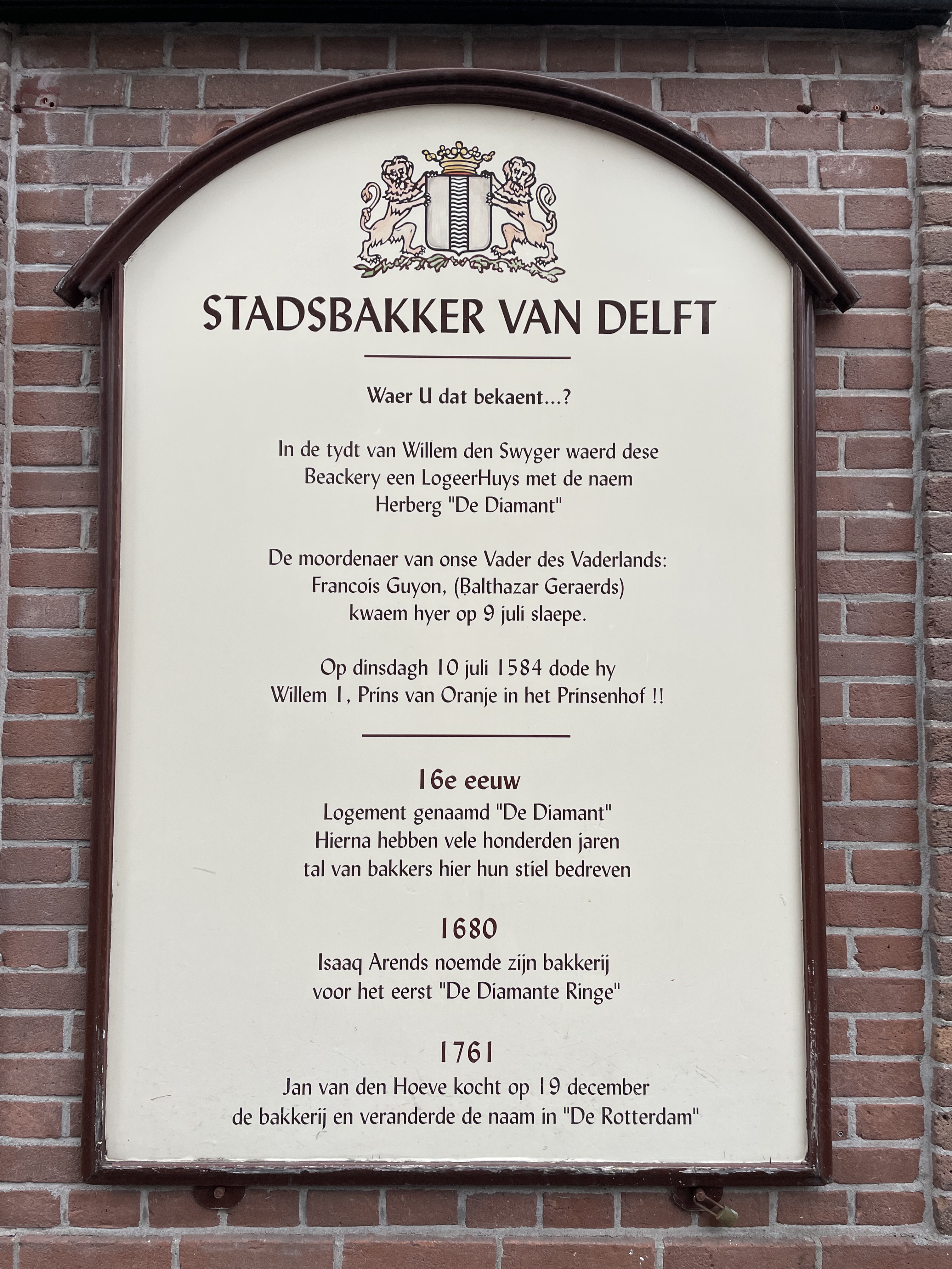
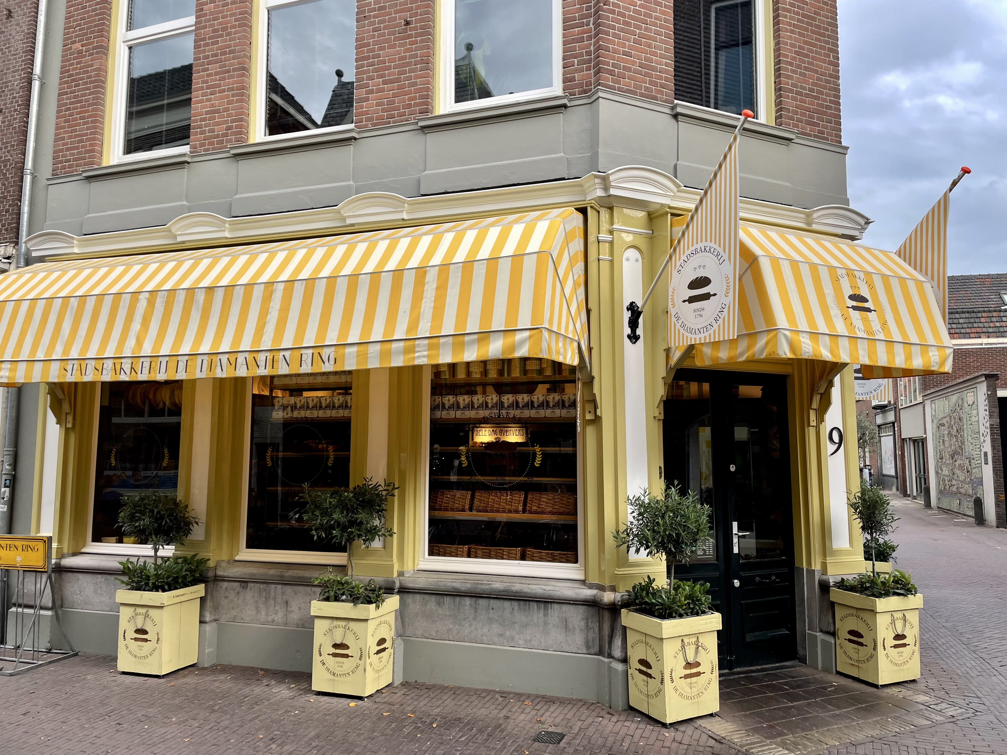
Willem joined and then led the uprising and turned on his previous masters leading the Dutch in this revolt. Willem was subsequently declared an outlaw in 1580 by the Spanish King. He was assassinated by a Spanish assassin Belthasar Gèrard on the steps of his residence in Delft in 1584 and his remains buried in the tombs of the Nieuwe Kerk on the market square. Prins Willem van Oranje is generally seen as the father of the independent Netherlands. My daily walks take me past Prinsenhof, the residence of Willem van Oranje, passing the Stadsbakkerij which was the inn where the assassin Belthasar stayed on his murder mission and over the Marktplein in front of the breath-taking Nieuwe Kerk.
When Jan landed at the Cape of Good Hope 68 years later, and built his castle, the five bastions, Oranje, Nassau, Leerdam, Buuren and Katzenellenbogen, were named after Willem.
‘Foreshore’ a last little bit of castle trivia; did you know that the Kasteel de Goede Hoop was originally on the water’s edge, but land was reclaimed in the so-called Foreshore Plan in the early 1900s, which ‘moved’ the castle inland by about 1 kilometer?
While I’m sitting in the quaint Eetcafé de Ruif staring over the old canal in Vrouwenrecht (street), I’m reminacing over my Texels ‘Skuimkoppe’ beer (genuine, that’s the beautiful name). Its 5 April, and tomorrow its 370 years ago that Jan van Riebeeck landed at the Cape of Storms aka Cape of Good Hope. I suppose it depends whether you’re a glass half empty or a glass half full type of person which name you use the most often.
Jan left for the Cape of Good Hope from Texel island on 24 Dec 1651 and set foot to shore in Vals Bay on 6 April 1652. Jan grew up in Schiedam, a town just outside Rotterdam through which I commute daily. He joined the Vereenigde Oost-Indische Compagnie (VOC) in 1639, and I can just presume that he either worked at or at least visited the company’s Delft offices many times. 850m from where I’m sitting is the Oost Indiëplaats and the old offices of the Dutch East Indië Company’s Delft offices. The VOC is still believed to be the biggest company to have ever existed.
Some further info and reminiscing: The VOC (Vereenigde Oostindische Compagnie) became so big that they, as a listed company had their own ‘military’ fleet to protect their trade. As a company, they even declared war on governments of countries. However, they became so big that the costs to protect their trade actually liquidated them in the end.
I have researched my family tree, and I know that my great great (not sure how many greats are required here) grandfather joined the VOC as a ‘dragonder’ which is basically a soldier, and he landed in the Cape in 1796, just three years before the VOC went bankrupt. I like to think his (huge) salary is therefore partly to blame for this financial downfall of the largest company ever.
So my question is; what did ‘oupa’ spend my inheritance on, cause I ‘ain’t seen nothing yet?’
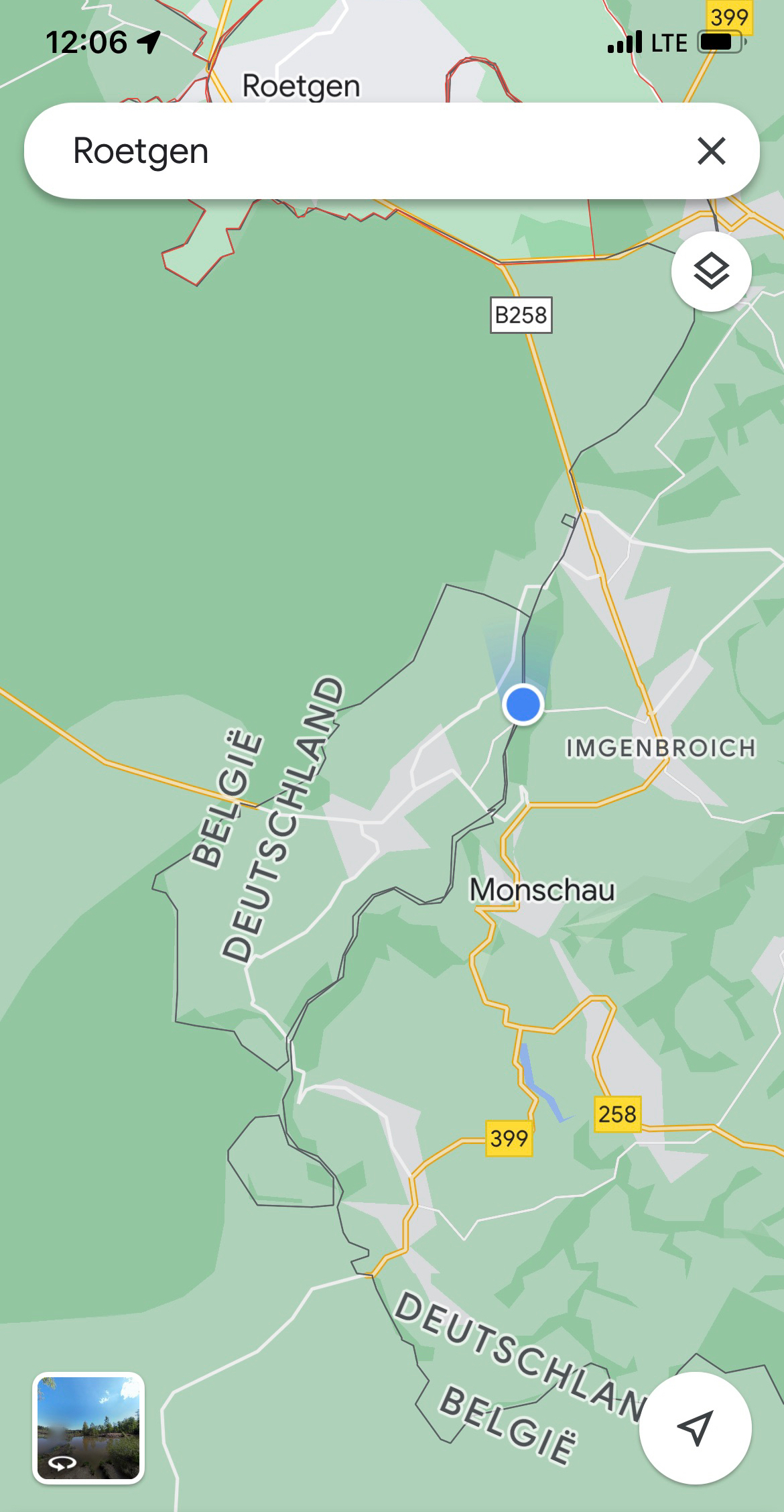
Though most of Europe is nowadays a union, their individual country borders are still very important. Trust me, I have witnessed it this weekend while camping in the picturesque Monschau area of the Eifel. A Dutch guy parked his caravan with the entire a-frame encroaching into the neighbouring German lady’s camping site, and she had none of that (understandably). After an amusing (for me), but serious altercation, and campsite management intervention, the Dutch guy was defeated, and with a lot of ‘brom-brom-brom’ had to swing his caravan by 90°. Only then peace and quiet once again dawned on this little piece of European Union.
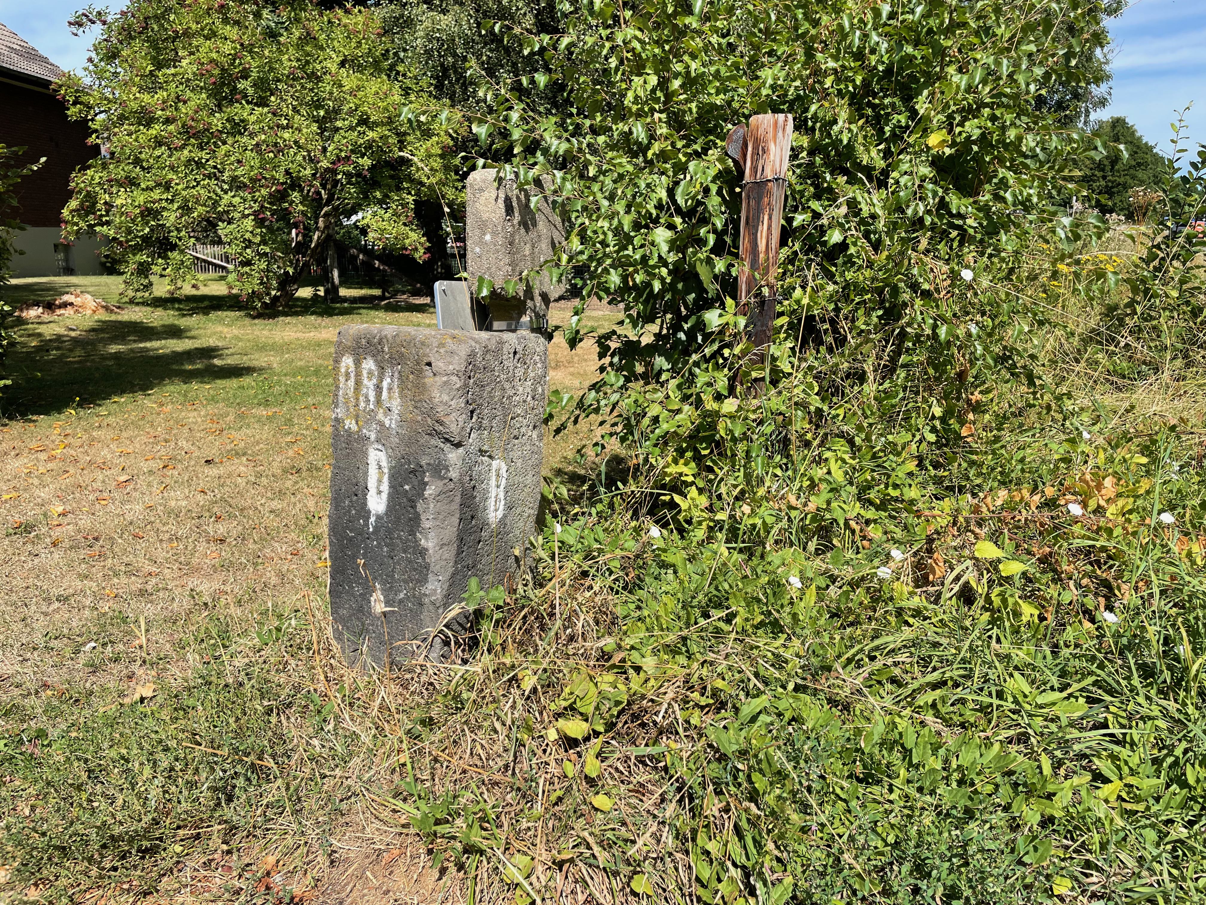
There’s a fascinating piece of borderline between Belgium and The Netherlands at Baarle-Nassau. Baarle-Nassau is closely linked, with complicated borders, to the Belgian exclaves of Baarle-Gertog. Baarle-Hertog consists of 26 separate parcels of land. Apart from the main parcel, known as Zondereigen and located north of the Belgian town of Merksplas, there are 22 Belgian exclaves in the Netherlands and three other parcels on the Dutch-Belgian border. There are also six Dutch exclaves located within the largest Belgian exclave, one within the second largest, and an eighth within Zondereigen. The smallest Belgian parcel, locally named De Loversche Akkers, measures 2,469 square metres – or if it actually is square, it means 49.69m x 49.69m! In political geography, an enclave is a piece of land that is surrounded by a foreign territory.
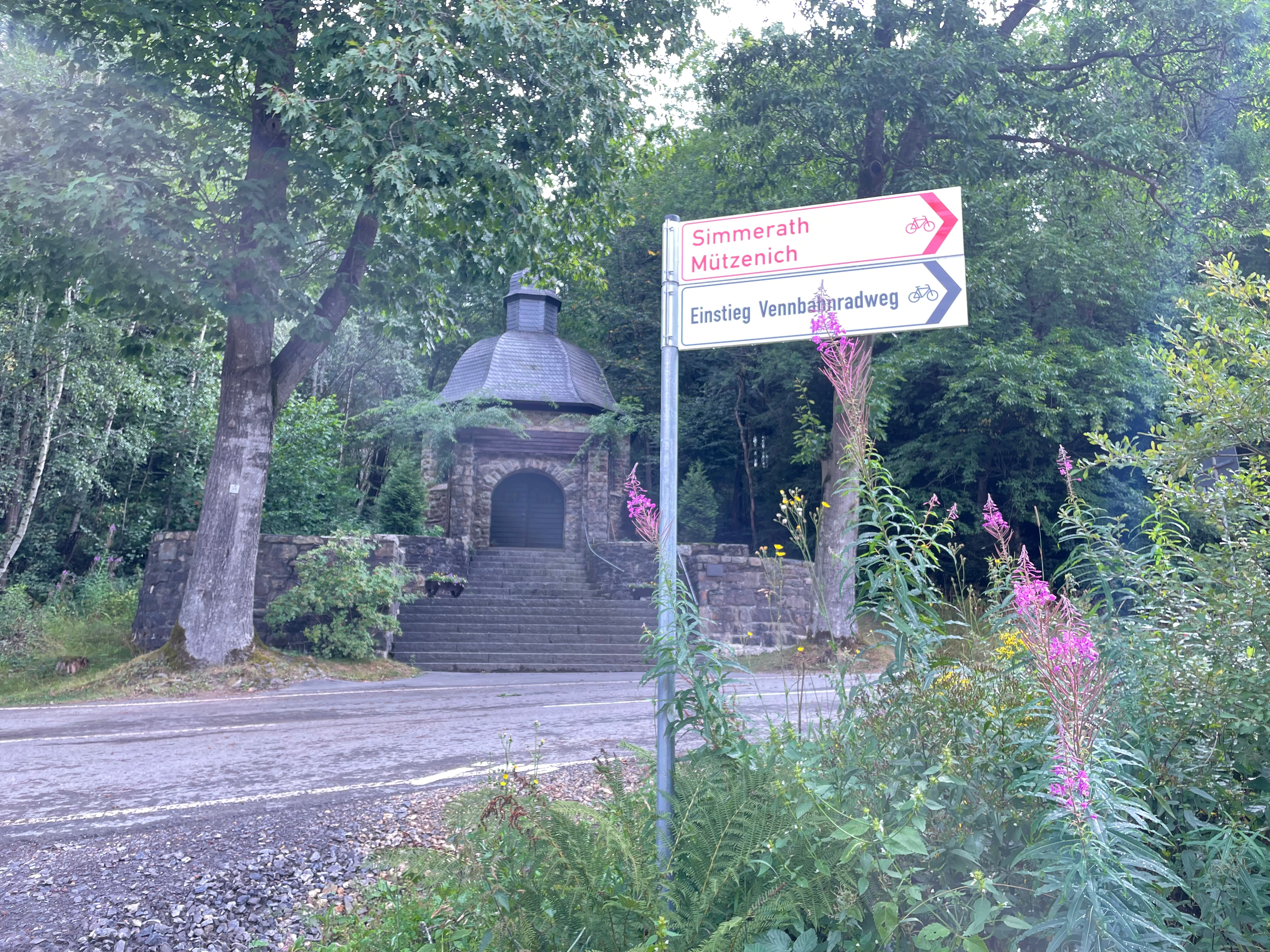
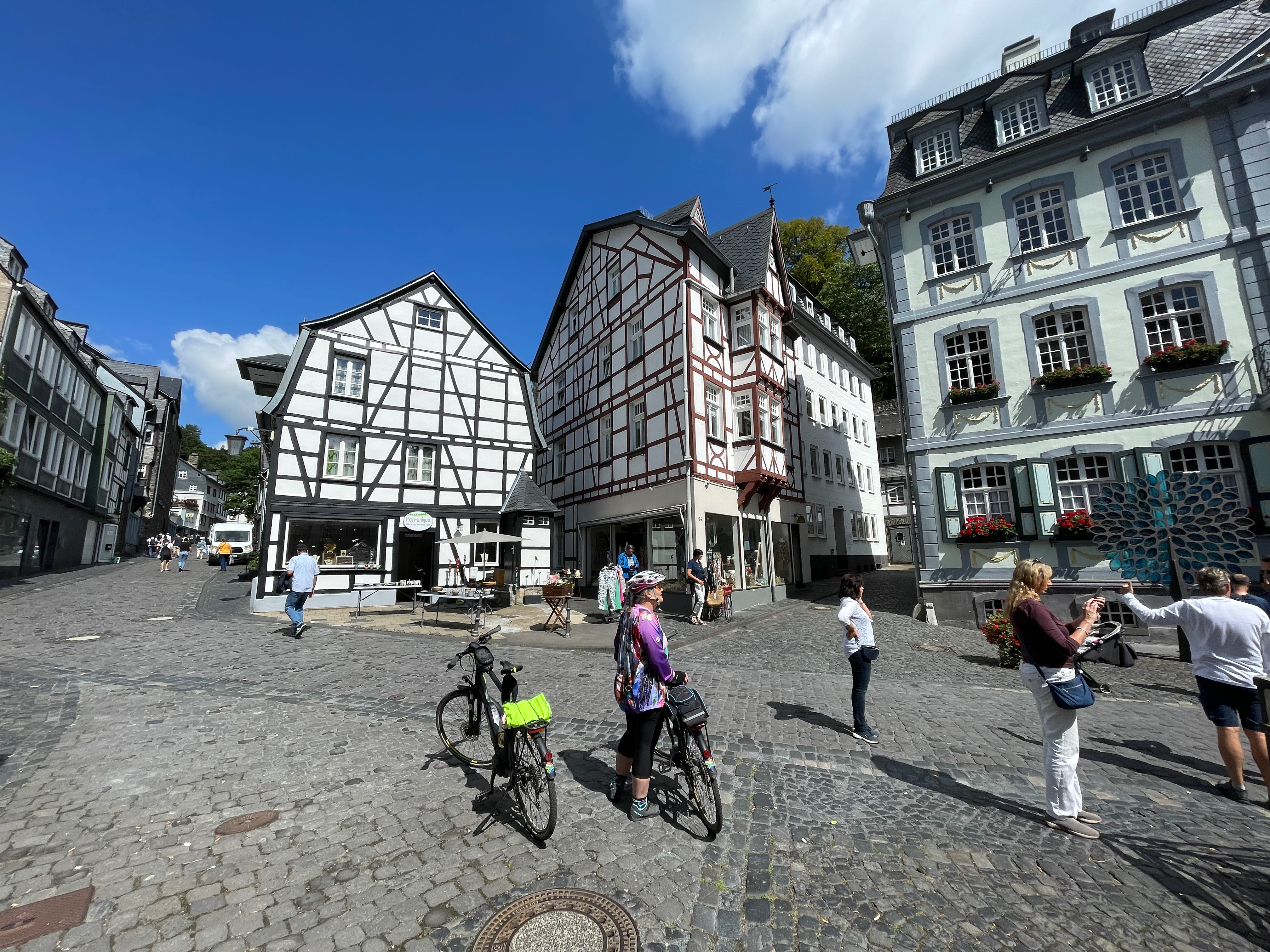
On the German Belgian border, where Heleen and I spent three wonderful days of cycling, there are similar, though not as complicated, borderlines. I have previously written about the delightful Vennbahn cycle route and these enclaves, so apologies for the repeat, but it’s such a delightful cycling area, please bear with me.
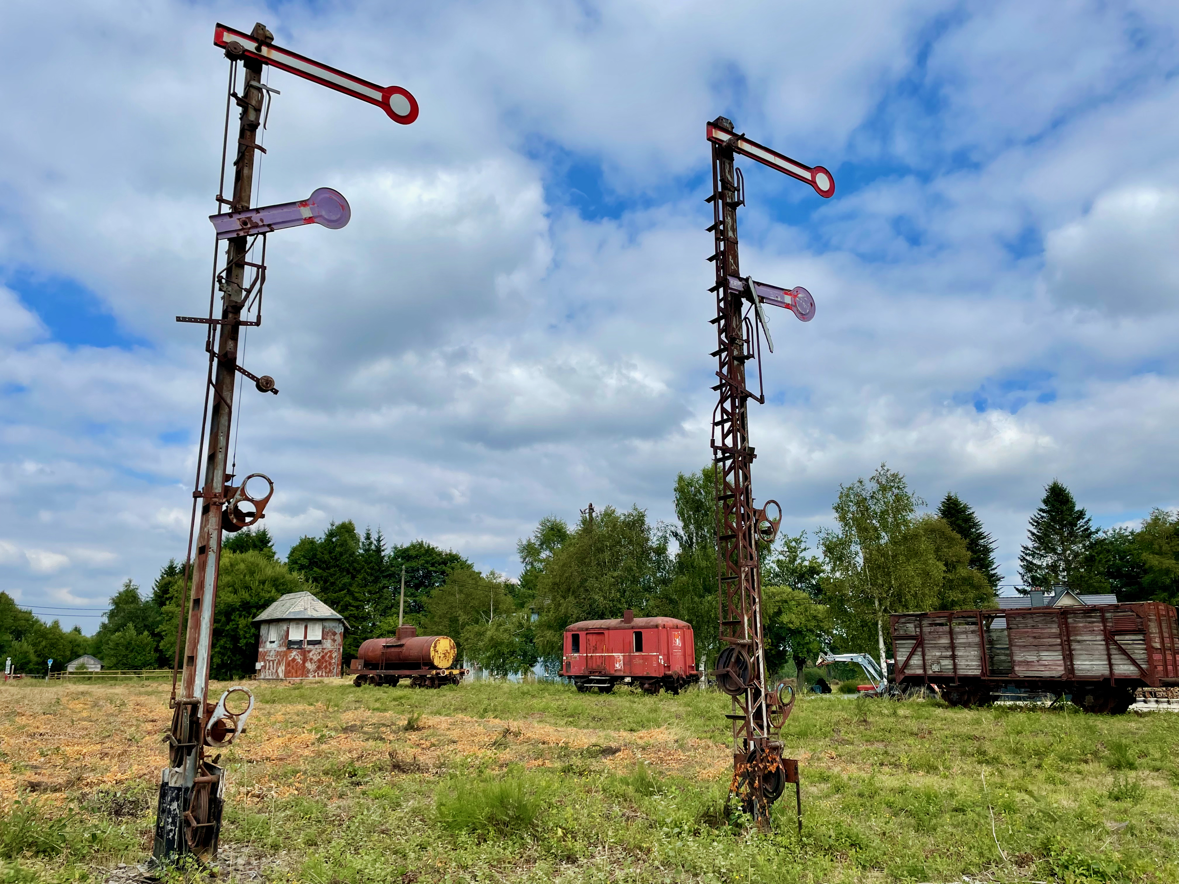
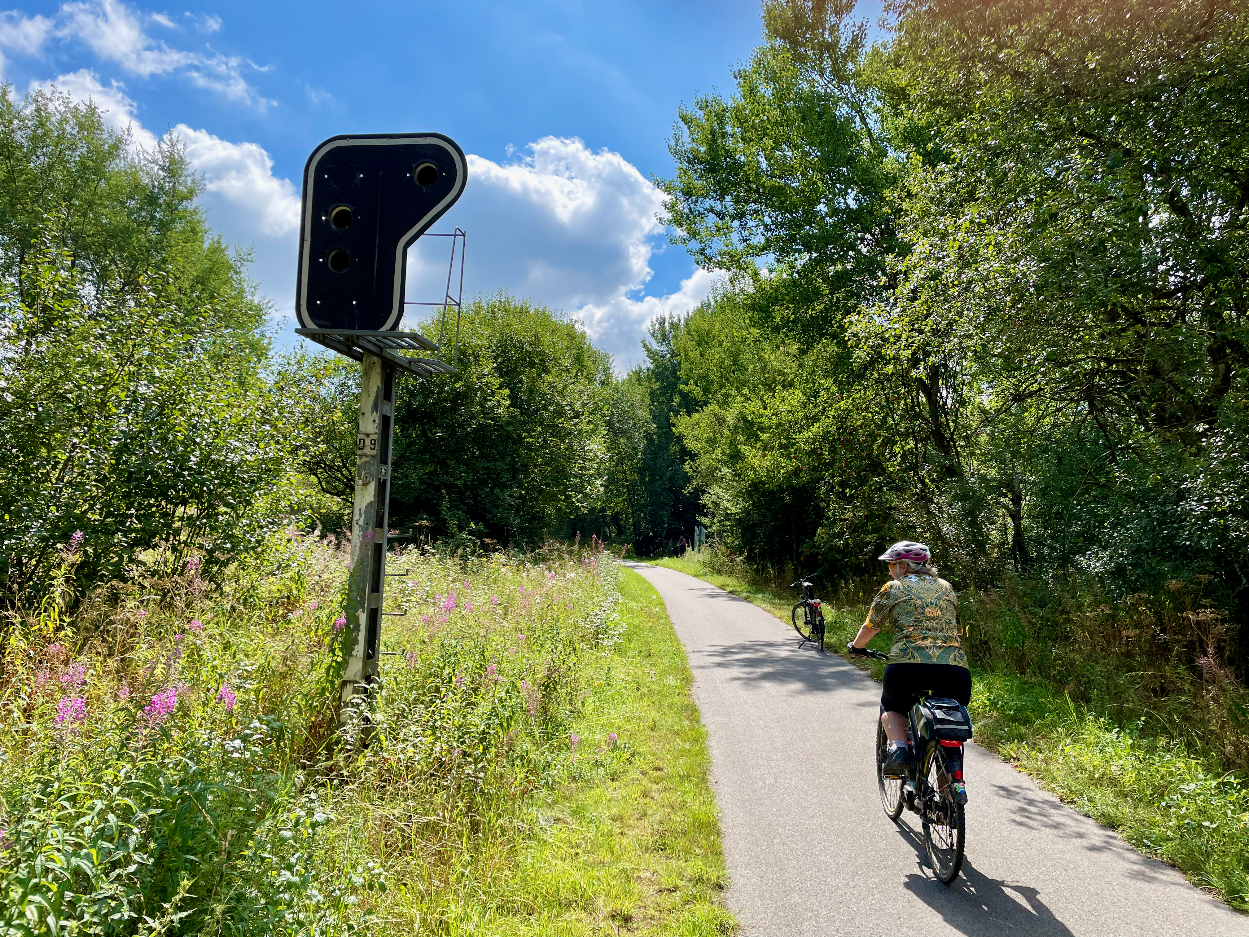
The Vennbahn or Venn Railway route has been Belgian territory since 1919, under the Versailles Treaty. It was originally built by the Prussian Government to primarily transport coal and iron, roughly between Aachen and the north of Luxembourg. When the Treaty became permanent in 1922, it meant that five enclaves of German territory (originally six) were formed, with the ‘bahn’ (railway track) a thin line of just a few meters of Belgium with Germany on both sides. The smallest German exclave, Rückschlag, consists of a house and a garden, some 155m x 100m according to my rough Google Earth measurements. I think I love cycling the Vennnahn cycle route for the feel and history of it because of the stunning railway remnants still visible; from old station platforms, railway signal posts and stop lights to the old station buildings. Maybe I love it for our daily stop at Kalterherberg station’s Waffelhaus for a cappuccino and sometimes a Belgian waffle, which really is so much better than any other waffle in the world; except maybe the Scottburgh Wimpy in the early 80’s?
A practical benefit of the open borders nowadays – on Sunday we stopped in Roetgen at a small supermarket to by an onion and iced coffees. The ‘left’ side of the road was in Belgium, where shops are open on Sundays, while across the road on the ‘right’ side, the shops were closed, because in Germany, the shops are closed on Sundays. We had onion on our burgers that evening, and ‘woema’ in our tanks for the Hautes Fagnes climbs ahead.
The area of Belgium is known as the Hohes Fenn, or Higland Moorland. The highland moor, which acts as a natural water reservoir, is the source of half a dozen rivers, including the Rur, Olef, Warche, Schwalm and Our.
The area where we cycled our 170km falls lock stock and barrel in the so-called Battle of the Bulge. The terrain is not all friendly and I indeed did battle with my bulge as well, but then decided I’ll only lose it if I stop those beer and waffle stops! Why would I cycle then?
The Battle of the Bulge was sort of Hitler’s last serious offense to try and prevent Antwerp as harbour to the Allies, before he hit the road, blew up the Bridge at Remagen as part of his retreat and took refuge in a bunker in Berlin for a while (not historically accurate, but you get my drift). However, it wasn’t all plain sailing for the American forces in this mountainous area. ‘The Hürtgen Forest occupies a rugged area between the Rur River and Aachen. This Rur is not the same river as the other Ruhr. The other Ruhr River has a ‘h’ in it, and is the water vein of that German industrial area which we all learned about in standard 4 geography. But this Rur is actually the same river as the Dutch Roer, and which flows into the Maas River at the stunning town of Roermond. In the autumn and early winter of 1944, the weather was cold, wet, and cloudy, and often prevented air support. Apart from the poor weather, the dense forest and rough terrain also prevented proper use of Allied air superiority, which had great difficulties in spotting any targets. The dense conifer forest is broken by few roads, tracks, and firebreaks; vehicular movement is restricted. Conditions on the ground became a muddy morass, further impeding vehicular traffic, especially heavy vehicles such as tanks’ (Wikipedia)
Its in similar terrain, bordering the Hürtgen forest in the Parc Naturel Hautes Fagnes or Hohes Venn where I battled my bulge, but on impeccable infrastructure. It remains, for me as a South African, incredible to be in fairly remote and secluded parts of these European forests, just to see a young lady strolling her Sunday stroll alone, and on two-meter-wide tarmac cycle roads for many kilometres, nogal.
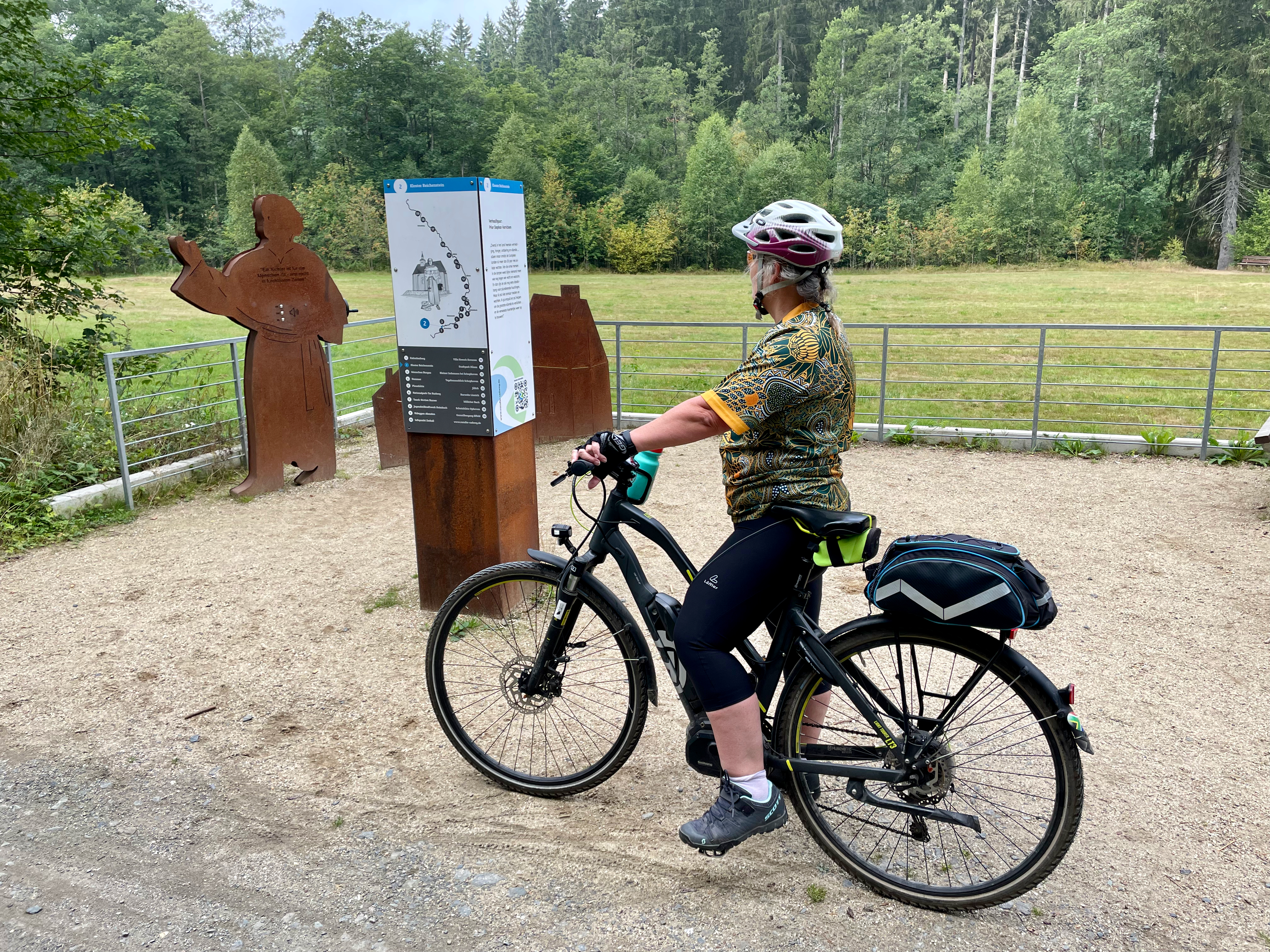
In the hilly forest of our daily start, is the interesting Kloster Reichenstein, which is currently being restored and where monks will soon again reside. In 1639, in the middle of the 30 year war, Stepfan Horrichem was put in charge of the Reichenstein Monastery as prior. Horrichem dedicated himself with full commitment to the consolation and assistance of the suffering population. Sometimes disguised as a farmer, he went from farm to farm and village to village to protect himself from infringement. In doing so, he earned respect, prestige and even admiration from the needy population. Next to the forest road, is a remembrance plague to Prior Horrichem, which unfortunately reminds us of the many many conflicts of Europe, as we actually see in the Ukraine at the moment.
You don’t have to be a cyclist, nor a camper, to visit and explore and enjoy this amazing part of Germany and Belgium, but to spend time in some of these slightly more remote nature-based camp sites in Europe, is highly recommended. The beautiful clean rivers, lush forests and green farmland hills all convert into real and peaceful scenic beauty.
I did find it rather funny. I know as a South African in Germany I don’t have a full understanding of history, geology, culture, past conflict, and context, but as we drove into Schleswig-Holstein, the Bundesland signage next to the road seemed a little near sighted, pun intended. ‘Schleswig-Holstein – der echte norden’ it said. Garmin profusely disagreed with a thick pink highlighted line and distance to destination clearly stating I had at least 2830km further to go to my ‘echte norden’ destination; The Nordkapp in Norway. I was wise enough not to be disappointed that I have ‘reached my destination’, and that I’ll have to stop enjoying a road-trip in my brand new LenieBus.
In German they refer to it as a ‘Kastenwagen’. In English we can therefor probably call it a Box Van, or maybe a Box Wagon, Panel Van, or Box Truck. If this was the 70s, maybe Passion Wagon or something similar that rhymes with truck. Whatever it’s called, it’s a midsized RV (Recreational Vehicle/motorhome) which puts us straight into the popular culture of van-life. LenieBus is our most recent travel equipment upgrade.
Heleen and I started our camping life and trips with borrowed tents, cooler boxes, sometimes Ventertjies (South African brand trailers), and flat cars such as VW Golf, VW Jetta or similar. It was fun and simple and allowed us to see many places. However, in South Africa, there are so much more to see and experience if you have off-road and dirt road capability, and thus we upgraded in 1998 to a VW Syncro Bus, but still sleeping in pitched tents and on the floor using blow-up mattresses. By then, we have become a family of four and in 2003 we upgraded to 4×4 ‘bakkies’ (pick-up trucks) when I bought my Echo 3 Off-road trailer with rooftop tent and my first Ford Ranger bakkie. We were kitted out and conquered every inch of dirt road, from ‘Kaap’ to Kalahari, Kruger to Molopo, Mapungubwe to Keimouth and ventured into the fantastic neighbouring countries like Swaziland, Botswana and Namibia.
We now live in Germany, and camping and road-tripping is slightly different than in the ‘platteland’ (rural) areas of South Africa. For starters, you really must go far and wide, and with a pinch of luck, to find a dirt road. Off the beaten tracks are however plentiful and within mainland Europe you can cover decent distance when you’re in the mood.
I was in the mood.
‘Let’s head north’ said Heleen.
‘Okay, but let’s go all the way north’, I replied.
Our great Nordkapp road-trip was now reality. Nordkapp is Europe’s most northern point. After all kinds of delays with the delivery of LenieBus, we eventually received her keys and the go-ahead that she is now ours from Herr Dahlem at 15:00 on 2 August. We loaded stuff for a three-week trip and by about 21:00 we hit the road. That night we had our first ‘vanlife’ experience of sleeping in the parking area of Rastplatz Stettin, 181km from home on the A1 heading north, en-route to way beyond ‘der echte Norden’.
Allemannsretten (meaning “everyman’s right”) is a law that allows everyone to roam free on uncultivated land in Norway. … In practical sense this means that you are free to hike, camp and enjoy the fresh air in forests, mountains, and coastal areas, which make up most of the Norwegian nature, and for free nogal. This is what LenieBus enables us to do, and we were going to exploit this fully. Cara took it on herself to be the finder of great nature and secluded camping spots using mobile apps such as Park4night and Caravanya and after a stunning day of driving 830km in Germany, through Denmark and over and under the sea between Copenhagen and Malmo in Sweden we rolled into a beautiful nature spot called Rövarekulan for a well-deserved night’s sleep. One thing that I’ve learned in Europe, and on that day as well, is that the scariest people you meet while traveling are these young blonde police women manning the border entries in Europe. Four South Africans driving a van on SA passports in Scandinavia raised suspicions with this Swedish cop and it took decent scrutiny, computer checks and all for her to wave us away after about 20 minutes, looking a little jealous of the adventure that awaits us.
It was with a deepened sorrow that I drove north on day 3. I just received the news of the passing of Prof Johannes Hatting, a friend of mine from the ‘Kampvuur’ chat group, to which I belong. Johan was a professor in travel and he specialised in the Boer War history, mostly in and around Bloemfontein. The last message Johan posted in Kampvuur read ‘Ek stry hom al di (sic) afgelope week. Dis n fokop’ referring to his battle with Covid19. Johan passed away on 4 August, and is missed.
Planning trips generally are easy. You determine where you want to go, enter that into Google Maps or your Garmin and divide that reported distance by 100 to give you estimated driving time. Ouma Koekoe will differ with my calculation though, as I tend to wander even when driving, and she’ll instinctively know that my 8 hours will turn out to be 10 or more hours. However, Sweden and Norway taught me a valuable new reality. Even if it’s tarred and national roads, not all roads are equal. If you manage an average of 70km/h you can count yourself lucky. So my 3163km from home to Base Camp in Skarsvåg reported by Google to be 36 hours of driving does not equal my planned 4 days. It turned out to be day seven when we arrived at Skarsvåg which would be our Base Camp for the next three days. I should be fair to the roads however and confess that the slow drive has a lot to do with the immaculate scenery, a hotdog or two or six, the euphoria of the entire trip, the constant stop for photos at spots such as entering the arctic circle, the first sight of a real fjord, reindeer, to celebrate the Springboks’ series win over the British and Irish Lions on the shores of the Barents Sea in Altaelva plus the constant search for moose, bears and even wolves. We all realised that the chances of seeing bears or wolves from the seat of your vehicle on a public road were very slim, but I really expected to see a few moose. The proof was clearly visible that they are there by the number of spotlights on all the local vehicles, even the sedans.
So far, we had 6 nights in LenieBus, with just the one night in a caravan park. The others were all wild camping, of which three were exquisite nature spots next to lakes or in woods. One was next to the road because I decided before the time, as a matter of trip principle, that I do not want to drive after sunset. Though LenieBus have seats for four adults, the extra two passengers, my adult children, had to pitch a tent every night. For them it probably was a bit of a schlep, but for Heleen and me, sitting on a camp chair with a beer watching them pitch their tent, it was no schlep at all. Camping was now really easy. As Johan Bakkes wrote in a review in a South African magazine, camping with a campervan remind you of a tortoise, ‘you’ve got your house on your back’. You just pick a spot, push a button to let the little step shift out, so that you don’t pull a hamstring when you reach for the fridge, and open two camping chairs and two beers. The children will bring their chairs when their tent is pitched.
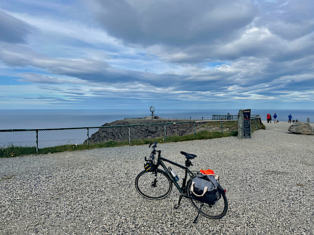
Day 1 at Base Camp camping site in Skarsvåg was supposed to be to do laundry and freshen up, but we had such a good camping spot and such good weather, that we sort of just sat around, enjoyed a lazy brunch, some short distance cycling and obviously threw some meat on the grill for a leisurely braai, while even having a swim in the arctic water of the Storvatnet lake on our doorstep. Day 2 was a little more serious, but this was why I brought the four bikes along. From Base Camp, it’s a further 16km to the actual Nordkapp, and this I wanted to do by bike – a nice leisurely 32km roundtrip with a total elevation gain of 721m. Nordkapp is situated at N71°21’10” and is the most northern point of Europe; thus for me it was a real bucket-list tick-off objective. To put this location into South African context; if I would go to 71°21’10” South, I would actually be on ‘dry ground’ in Antarctica, roughly 4070km south af Cape Agulhas! That’s a cool travel thought for me. (Africa’s most southern point at Cape Agulhas is at 34°49’59,6”).
“To move, to breathe, to fly, to float, to gain all while you give, to roam the roads of lands remote, to travel is to live.” (Hans Christian Andersen)
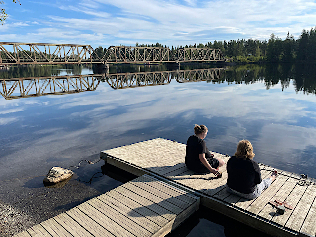
Turning south from Nordkapp I did some brief estimates and realised we had two weeks to get back home in Germany, but there were many things I wanted to see, places to stop at and photos to take. We could fortunately build in a few detours and there’s enough time to head south-west through most of Norway and visit places such as Lofoten, Bergen, the Trollstigen and the Preikestolen, to name just a few, … and which we did. Norway must be one of the most beautiful countries in the world. The scenic splendour is endless, the 1700 named fjords range from the massively large Sognefjord which stretches 204km inland to the narrowest Nærøyfjord which spans a mere 500m in width at some places. The European Road E39 is the main road leading south, but it is by no means a highway. Traveling at averages of about 60km per hour is common, and you should not be in a hurry when you decide to road-trip in Norway. Heading south we leisurely meandered and attempted wild camping as often as possible. It’s hard to highlight the best overnight stops but worth specific mention are the nights
next to Fjord Kjaeken, facing west and just enjoying the sunset at about 23:00, while a bottle of Roodeberg, two otters and some dolphins add to the tranquility, plus here I found some dirt road,
the night at Vevang on the Atlanterhavsveien or Atlantic Ocean Road with those magnificent sea crossing bridges,
the night next to a remote road on the banks of Dam Sunnfjord and swimming in the icy waters for the brave amongst them (or stupid?),
and the camping in basic campsites such as
Solnaset Gard (farm), and
The Preikestolen campsite where the owner who frequently travels to South Africa and the Kruger National Park, actually installed braais similar to those well-known ones the South African Parksboard have in all their camps.
Lofoten is an archipelago located at the northwest of Norway, where the dramatic mountain- and sea views are never ending, and where the entire peninsula is lined with picturesque fishing villages. Probably the most famous and definitely worth the visit is the town Henningsvær, with its soccerfield virtually build in the sea on a small peninsula. A fascinating learning experience, and excellent thick vegetable and reindeer soup, is available at the Lofotr Viking musem, with its restored longhouse and Viking boats. This house belonged to the powerful Chieftain of Borg and dates from the years 700 AD. I am not sure what Borg’s relationship was with Ragnar Lothbrok and his sons was, but Borg himself had quite a dwelling of note.
When traveling in Norway, you are going to use ferries and toll-roads, and its completely justified when you consider the infrastructure of these tunnels and ferries and time saved by using them. With some routes it simply is not wortwhile to search for alternative routes, and though some bloggers and travel writers criticise the cost, in the end I didn’t think it was overly pricey. On most of the toll-roads and ferries, you simply use them, and get billed later. Photos are taken of your car registration, and the bill is then posted or emailed to you. Its wise to preregister on the website of the Toll Collection company Epass24 and just let the transactions get paid automatically from your preregistered credit card, at a discounted tariff because you’ve registered. Below is a summary of my toll and ferry costs.
One or two toll gates were paid in cash though, including a real expensive €125 for the road crossing between Denmark and Sweden, as well as the ferry crossing between Norway and Denmark (Kristiansand to Hirtshals).
Part of travel experience is obviously to enjoy local cuisine and learn a little about the tastes, flavours and sources of sauces of the country. Since we were on a self-catering self-drive adventure, I can confirm that Cara makes a mean spaghetti bolognaise, Heleen all kinds of traditional ‘padkos’, Stean a mean ‘braaibroodjie’ and I can still ‘braai’. We did now-and-then eat out and in Norway you have plenty of excellent fish, reindeer meatballs with sauce (called kjøttkaker) and potato dumplings (called raspeball), stew (called lapskaus), and lingonberry cream (called trollkrem) for dessert as local dishes. However, by far the biggest traditional dish, from our personal experience are hotdogs. To Norwegians ‘hotdog’, is like ‘braai’ to South Africans; the go-to solution to everything. Hotdog is not really a verb, but in Norway it is. We hotdogged a lot. It’s not a massive exotic hotdog at all. As a matter of fact, its smallish, with the bun way too small for the sausage, but its tasty, with a choice of sauces and I think the big selling point is the bun is soft, not one of those palate breaking baguettes that frequents most of Europe’s bakeries. Don’t get me wrong, there is nothing wrong with a fresh baguette, but if you have them too frequently, you kind of end up looking like Dracula with the blood from your cut palate streaming from your mouth; and it hurts! These Norwegian hotdog buns are like freshly washed thick towels emerging from the tumble dryer, compared to wind dried towels washed with Sunlight soap in a river. To elaborate more on this, should rather be left to the professionals, and thus I refer you, to https://www.scandikitchen.co.uk/hotdog-scandinavian-way/ though I can affirm for the Norwegian hotdog as being the go-to snack, every time you stop for fuel, coffee, groceries, or, … er, well, when you stop. Its dirt cheap, delicious, and available everywhere.
Atlanterhavsveien or The Atlantic Ocean route is a roughly 9km road between the towns Kårvåg and Vevang. The road runs across an archipelago of partially inhabited islands and skerries and consists of eight bridges, four resting places and plenty of dramatic scenery. We traversed the road on a beautiful summer’s day with a calm sea and absolute exquisite scenes of natural beauty around us. We stopped, probably had a hotdog, and drove parts of the route more than once just to provide the opportunity to take it all in, and to let the drone do it’s thing.
When you think of the tourist attractions of a nature paradise such as Norway, there obviously are a few that form the basis of your trip planning. Nordkapp, a couple of fjords, Atlanterhavsveien, Trollstigen and the Preikestolen were sort of my reference via points to plan my route on. It doesn’t mean that’s it, as everything in-between is just pure splendour (remember that I’m talking 8327km here). However, you should at least plan for these four, and the fortunate thing is that you will see a couple of fjords in the process.
Serenity
After a stunning drive from Lofoten, which included the Atlanterhavnveien, we found a secluded wildcamp site next to a small road and sat down to reminisce about everything we have seen, and still are experiencing.
“I have found out that there ain’t no surer way to find out whether you like the people or hate them than to travel with them.”(Mark Twain)
I love them.
Time was starting to become an issue, traveling was slow, and the road home still far. But I had two more sights to see, and I was adamant.
The Trollstigen is a famous serpentine mountain road and major tourist attraction due to its steep incline of 10% and eleven hairpin bends up a steep mountainside. It is the ascent (or descent) at the end of the beautiful Isterdalen (valley) which, while driving the pass, provides excellent views of the valley as well as the Stigfossen waterfall. Trollstigen means the troll path or troll trail. I’m not sure what Norway’s big thing with trolls are?
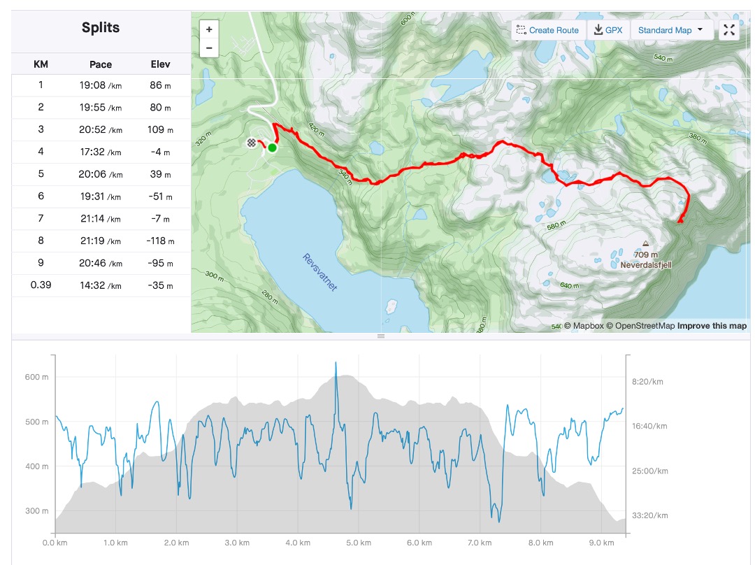
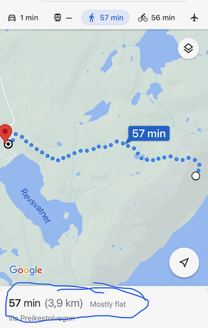
At the foot of the trail to the Preikestolen (Pulpit rock) is the Preikestolen camping ground. We arrived in the afternoon, and were slightly under time pressure, since we wanted to visit the actual pulpit rock that same day, so that we could travel home the next day. We (I mean the children) pitched their tent, and we put on our walking shoes. I consulted Google Maps and planning fell into place – 57min walk, Google said, 3.9km Google said, and ‘mostly flat’ Google said. Google lied! However, after a 9.6km roundtrip (4.8km one way) and a climb of 605m and a 3:06:05 moving time (3:52:57 elapsed time), I opened a beer very very satisfied back at the campsite. We were tired, but happy. The scenery is out of this world, the last tick-box of our Norway trip was ticked off and we sat around a campfire build on a Kruger National Park lookalike ‘braaier’. The owner of the campsite is a fond traveller to South Africa, and he particularly loves the Kruger National Park. So much so, that he installed similar braaiers in he’s Norway camping ground.
I was happy and I felt extremely blessed. Except for two more days of driving, this was the end of an absolute epic and wonderful family holiday.
Now, as I write this trip report in my warm lounge at home on this freezing December morning, I cannot wait to turn LenieBus’s nose in some new direction and get going again. I must remember to order a case Springfield The work of Time.
‘Okay, but let’s go all the way north’, I replied.
Everybody has some sort of travel wish list, and since I landed in Europe, 10 years and 3 days ago, driving to the Nordkapp, Europe’s most northern tip, have been one of my tick-box items.
Coming to a screen near you very soon, will be the trip report, photos and video footage of an epic 8327km driven to the northern most point of Europe over a three week epic road trip.
We’ve set up camp in Wilderness for 10 days, and those 10 days were filled with mini road trips, as this is prime sight-seeing country, where mountains, forests, lakes, rivers and the ocean meet. This is where birds, rural coffeeshops, world-class restaurants, scenic dirt roads, mountain fynbos, Knysna Yellowwood forests all shout out for the traveller’s attention and where my daily ‘braaivleis vuur’ beckons to give flavour to those lamb chops Appie so lovingly packed.
As many of my Bonn based non-South African friends will probably confirm by now, having good quality meat and a decent ‘braai’ is very high on my list of quality time and soul finding activities. It’s not without good reason that the licking flames of a wood fire is often referred to as the bush television. As part of my initial trip planning I contacted Appie, a farmer and owner of Boeteka Padstal (32°30”08.83’S and 22°33”41.09’E) 18km outside of Beaufort West on the N12 towards Oudtshoorn and I ordered half a Karoo lamb, cut and prepared to my order, plus some prime T-bone steaks, boerewors and a Kudu fillet for a special planned dinner. ‘Baie dankie Appie, ons het soos konings ge-eet’. Check my next post which will include some time in Addo National Park, for feedback on Appie’s Kudu fillet recipe.
‘Diederik’ Cuckoo
Greater double collared sunbird
Ten days in Wilderness promised to be pure bliss, and yes it is such an incredible blissful place, it is actually spelt with a capital W. Wilderness or wildlands, according to Wikipedia are natural environments on earth that have not been significantly modified by human activity. This is not quite true. The Wilderness we were based at is the quaint anchor (pun intended) town in the Garden Route which nowadays provide abundant modernised human modifications such as restaurants and cafés. Wilderness is even more a prime destination for it’s natural splendour of forests, lakes, mountains, birdlife and ocean. Within an easy day’s travel, you have access to diverse environments, which includes the awesome Swartbergpas, Meiringspoort and Klein Karoo to the north and the Knysna forest, town and lagoon to the east, plus the lakes and Sedgefield with its weekly Farmer’s Market in between.
Please play the video
The Sedgefield market, though crowded and busy, is always a charming stop where I love to stroll, explore, smell, hear, see, taste and experience the variety of delights it has to offer. Here you can enjoy many wonderful products from fresh farm produce to samoosas, vetkoek, coffee, beer to biltong, (even) bratwurst, pannekoek and sweets while enjoying either the local Cape music, the new street children choir or the local hippy singing all the cool blues, rock and country from days gone by. The Sedgefield ‘markie’ does have one major disadvantage though. I tend to get stuck there enjoying the music sometimes to the annoyance of the rest of my travel party. It’s also an added pleasure when you bump into an old friend whom you’ve last seen in 2011, before moving abroad, ‘nè Lydia?’
“At first encounter the Karoo may seem arid, desolate and unforgiving, but to those who know it, it is a land of secret beauty and infinite variety.”
― Eve Palmer,Plains of Camdeboo: The Classic Book of the Karoo
Disclaimer note: I often use the Afrikaans terminology referring to this part of the world since I grew up with that terminology, and its been embedded as acceptable terms, e.g. veld – open, uncultivated country or grassland in southern Africa. It is conventionally divided by altitude into highveld, middleveld, and lowveld. There are other such terms I use throughout.
As soon as we decided to ‘go back home for Christmas’ I was in secret planning mode. And when Stean remarked, ‘I don’t really know the Karoo’, it was the last straw; my planning and dreaming and longing became acute. I asked Stean whether he wanted to see the Karoo and ‘He turned to me as if to say, “Hurry boy, it’s waiting there for you”
We’ve been living in Germany for eight years, and though we’ve been back home many times, we’ve not been there for Christmas – a summer Christmas with family and friends like the days of old beckoned. I knew the underlying idea was to visit family for Christmas, but my wanderlust convinced me very quickly that driving the 1338km down to the Garden Route should never be done in just one day. There’s just too many distractions, stops to be made, and I needed time to show my children the Karoo en route to Wilderness.
Enjoying the maize fields, irrigation system and wide open sky of the Highveld
I’m fortunate though, I have a brother who lives on the Highveld some 100km east of Pretoria, and a weekend relaxing there with a braai, good South African wines and long chats catching up on all and sundry to get rid of Europe’s cold before embarking on my road trip seemed the perfect start to 3 weeks of bliss in the South African ‘platteland’. The ‘Hoëveld’, or Highveld is that large portion of the South African inland plateau which consist mostly of rolling grassland and open open spaces.
In die Hoëveld, waar dit oop is en die hemel wyd daarbo,
Waar kuddes waaigras huppel oor die veld,
Waar ‘n mens nog vry kan asemhaal en aan ‘n God kan glo, …
Toon van den Heever
Very freely translated it will read
‘On the the Highveld, where its open and the heaven wide above,
Where flocks of waving grass skips over the veld,
Where man can still breathe freely, and can believe in God, …’
“Budapest is a prime site for dreams: the East’s exuberant vision of the West, the West’s uneasy hallucination of the East. It is a dreamed-up city; a city almost completely faked; a city invented out of other cities, out of Paris by way of Vienna — the imitation, as Claudio Magris has it, of an imitation.”
― M. John Harrison, The Course of the Heart
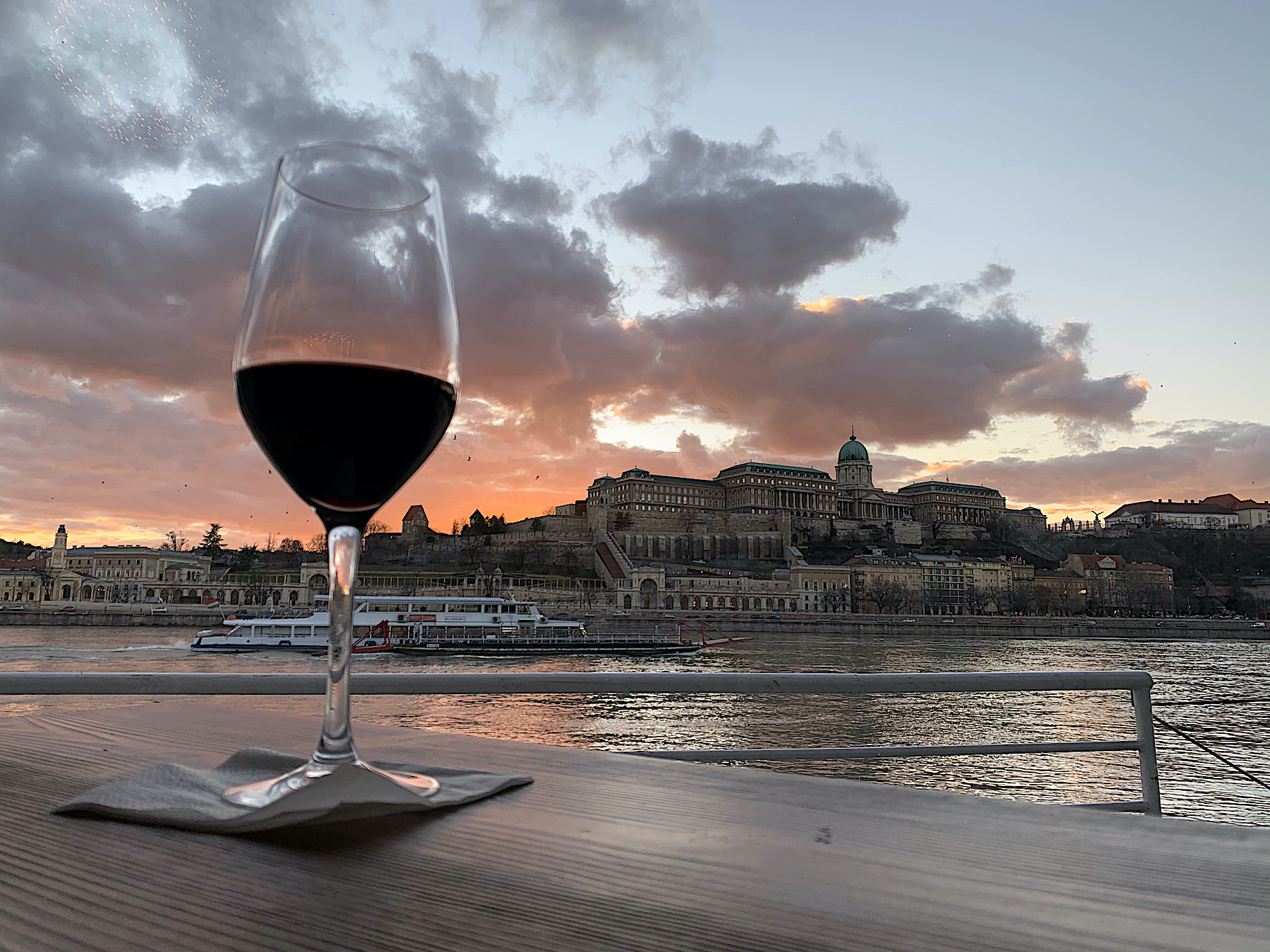
Well, I’m not sure, and to be fair the quote does stem from 1992, but what I am sure about is that visiting places for a third time is a privilege providing opportunity for looking at the same stuff afresh. This was my third visit to Budapest, 26 years after my first.
My first visit was in January 1994, when Budapest and Hungary were actually still busy stepping out from behind the Iron Curtain. In those days you could still feel the cold eastern atmosphere in the Budapest streets. Strolling the streets in those days, you could see and feel the cold, grey and life’s weight on the residents but from a traveller’s perspective it was gloriously exciting. Since that trip, it has changed a lot. Budapest nowadays is a vibrant city, with a modern feel, many tourists ensuring the worldwide irritation of pedestrians texting while walking, selfie-sticks in abundance and English spoken everywhere. Don’t get me wrong when I refer to the latter negatively, but the globalised impact of being understood everywhere does dilute some of the traveling experience of old. It was exploratory on my first trip in 1994 to struggle being understood, adventuring through menus and using sign language to get to destinations or pointing at which ‘torta’ you want with your coffee. Nothing in Hungarian hints in any way to its English word, not to even think Afrikaans. Sitting in Ferenc Liszt Budapest airport just after arrival I was, for example, trying to find links between the Hungarian I saw on restaurant signs and English. Who would have thought that ‘péksütemények’ means ‘pastry’, or even shorter ‘deeg’ in Afrikaans? On that first trip, 26 years ago, there were no translate apps, no Googlemaps, nor commercial GPS’s, no Costas nor Starbucks and hardly any English; just the decent and proper ‘old world’ classy ‘cukrászda’ coffee establishments, such as Gerbeaud. Furthermore, in those old days, the clientele of Gerbeaud did not stroll in wearing hiking boots, loose hoodies and backpacks, they were dressed in old fashioned classy coats and scarves and vintage Fedora hats. In a sense, travel has become too easy, and dare I, who love wearing shorts, say, too casual?
Belgium was never particularly high on my list. I’ve always loved the relaxed passion of the Mediterranean nations, Italy, Spain, Portugal and Southern France; the language and ‘joy de vivre’ of France and I was naturally intrigued by the Afrikaans heritage from the Netherlands. To my layman’s understanding of Belgium and Luxembourg they were sort of the mix that wondered whether they were French, Dutch or German, not excelling at one of them, yet thriving on their political stance as home base of the EU. Last year’s trip, (see Summer in the sombre ‘The Somme’) to Flanders was the beginning of my enlightenment, but having spent a magnificent six days over Easter in the Belgian Ardenne, opened my eyes and made me realise that Belgium was a full longed and proper travel destination where you need time to meander, read, listen and just sit around to observe. It is rich in history (not all of it is good though), culture, engineering and finesse. Belgium is sort of my new Number One – sorry Jacob.
We were based in a gîte just outside of Bastogne called Savy555 (find Christine on Booking.com – I recommend that) with a cosy fireplace for the relaxed evenings, a nice ‘stoep’ outside with stunning views over the spacious lawns towards the duck pond end. To perfect the amenities, there is a small braai for the good weather dinners I prepared.
Braai ≠ barbeque nor grill, but for clarity’s sake, let’s use those synonyms if you’re not South African
Everybody has that one favourite T-shirt. Maybe you don’t even wear it anymore, for whatever reason. Maybe it is simply too worn-out or it has shrunk too much under your ageing belly, but you don’t have the heart to get rid of it. I have one too and mine has a quote, accompanied by the face of Nelson Mandela, stating
‘History depends on who wrote it’.
History may have two sides, but sometimes that history is simply so dark, so gruesome, that the different sides to the stories become irrelevant and the horror of the history is the only thing that stands out.
We loaded the grandparents and headed off to such an area, The Somme Valley in North Western France where that infamous battle raged from July 1 to November 1, 1916.
On 11 November this year, at 11:00 it will be the 100th celebration of the end of World War 1. That is the time and date when the armistice was signed between the Allied Forces and Germany – ‘on the 11thhour of the 11thday of the 11thmonth, 1918’.
We started with our round-trip by staying over in the Belgium beach town of Middelkerke. Though we enjoyed pleasant walks on the flat sandy beach with a backdrop of ugly Amanzimtoti style high-rise blocks of flats, I was aching to get into the hinterland and explore some battlefields. We found charming glamping tents on a pig farm Het Zeugekot (saying it like this sounds much less charming than it was), in Belgium near the small town of Beveren (Roesbrugge-Haringe), which was our base for a few days while we explored some battle sights, and the two charming charming cities of Ghent and Ypres. Be careful with some of these European landlords though. We unfortunately left the tent flaps open, as it was a sweltering heat wave of 39° C, and we weren’t back at the tent before a beautiful thunderstorm broke out. The storm did result in a couch cushion getting wet and needing a wash, but that little wash cost us the full deposit – a €150 wash that was!
Middelkerke beach and ugly Amanzimtoti like blocks of flats
Ypres (or Ieper in Flemish – it is located in West Flanders and called sarcastically ‘Wiper’ by the English during the War) was heavily involved in World War I as the Battle of Ypres seethed here. War cemeteries and even trenches can be seen and visited all over this area. In the town itself I was mesmerised by the ‘Menin Gate War Memorial to the Missing’. Its a war memorial ‘gate’ where every evening at 20:00 the ‘last post’ is sounded as a gratitude from the people of Ypres to those who sacrificed their lives in battle. Its large Hall of Memory contains names on stone panels of 54,395 Commonwealth soldiers who died in the Salient but whose bodies have never been identified or found – simply missing.


 can be seen and visited all over this area. In the town itself I was mesmerised by the ‘Menin Gate War Memorial to the Missing’. Its a war memorial ‘gate’ where every evening at 20:00 the ‘last post’ is sounded as a gratitude from the people of Ypres to those who sacrificed their lives in battle. Its large Hall of Memory contains names on stone panels of 54,395 Commonwealth soldiers who died in the Salient but whose bodies have never been identified or found – simply missing.
