Though most of Europe is nowadays a union, their individual country borders are still very important. Trust me, I have witnessed it this weekend while camping in the picturesque Monschau area of the Eifel. A Dutch guy parked his caravan with the entire a-frame encroaching into the neighbouring German lady’s camping site, and she had none of that (understandably). After an amusing (for me), but serious altercation, and campsite management intervention, the Dutch guy was defeated, and with a lot of ‘brom-brom-brom’ had to swing his caravan by 90°. Only then peace and quiet once again dawned on this little piece of European Union.
There’s a fascinating piece of borderline between Belgium and The Netherlands at Baarle-Nassau. Baarle-Nassau is closely linked, with complicated borders, to the Belgian exclaves of Baarle-Gertog. Baarle-Hertog consists of 26 separate parcels of land. Apart from the main parcel, known as Zondereigen and located north of the Belgian town of Merksplas, there are 22 Belgian exclaves in the Netherlands and three other parcels on the Dutch-Belgian border. There are also six Dutch exclaves located within the largest Belgian exclave, one within the second largest, and an eighth within Zondereigen. The smallest Belgian parcel, locally named De Loversche Akkers, measures 2,469 square metres – or if it actually is square, it means 49.69m x 49.69m! In political geography, an enclave is a piece of land that is surrounded by a foreign territory.
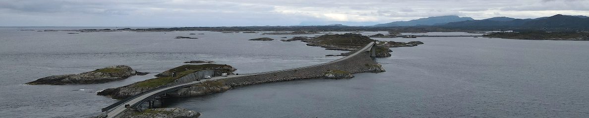
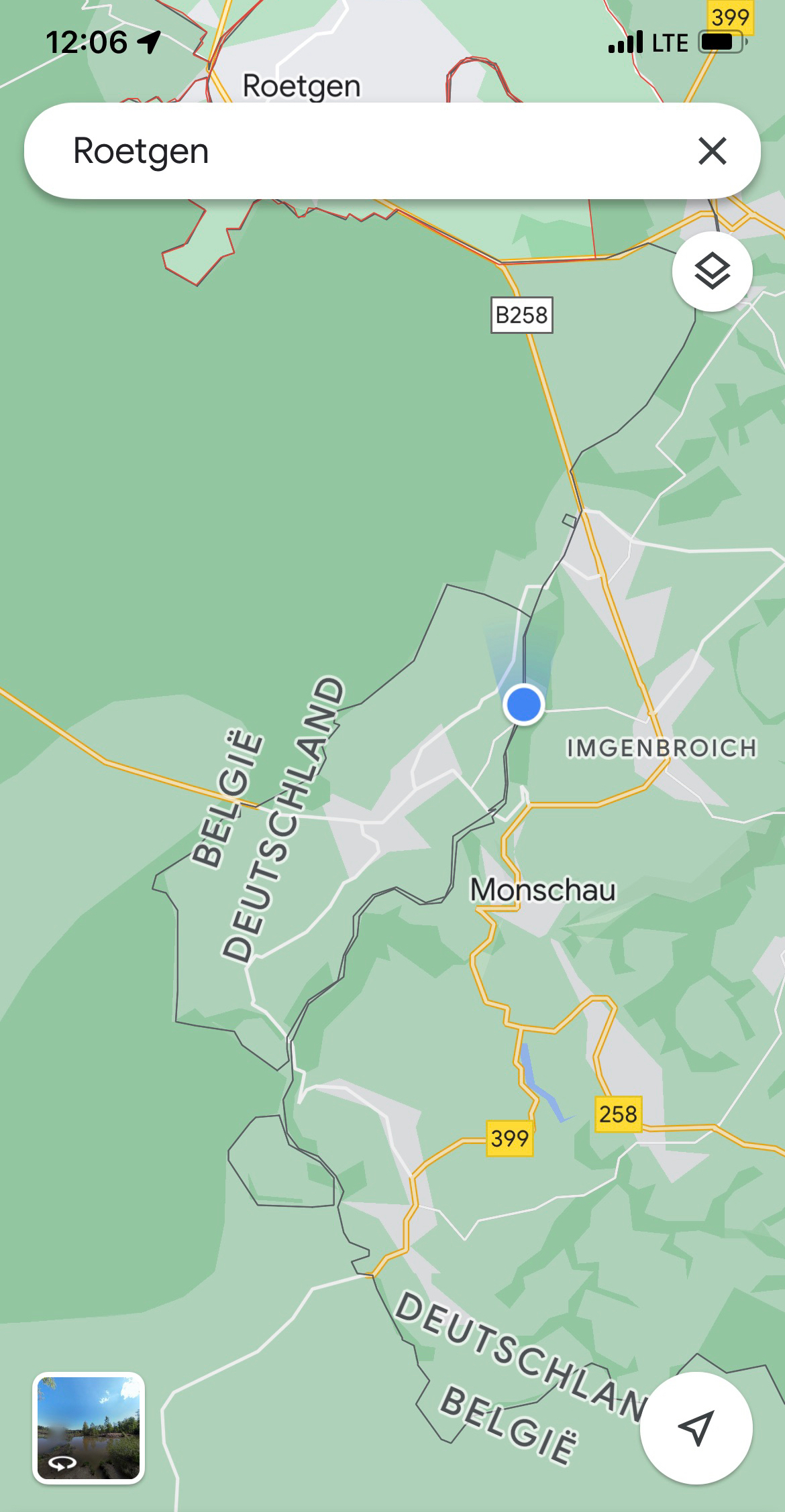
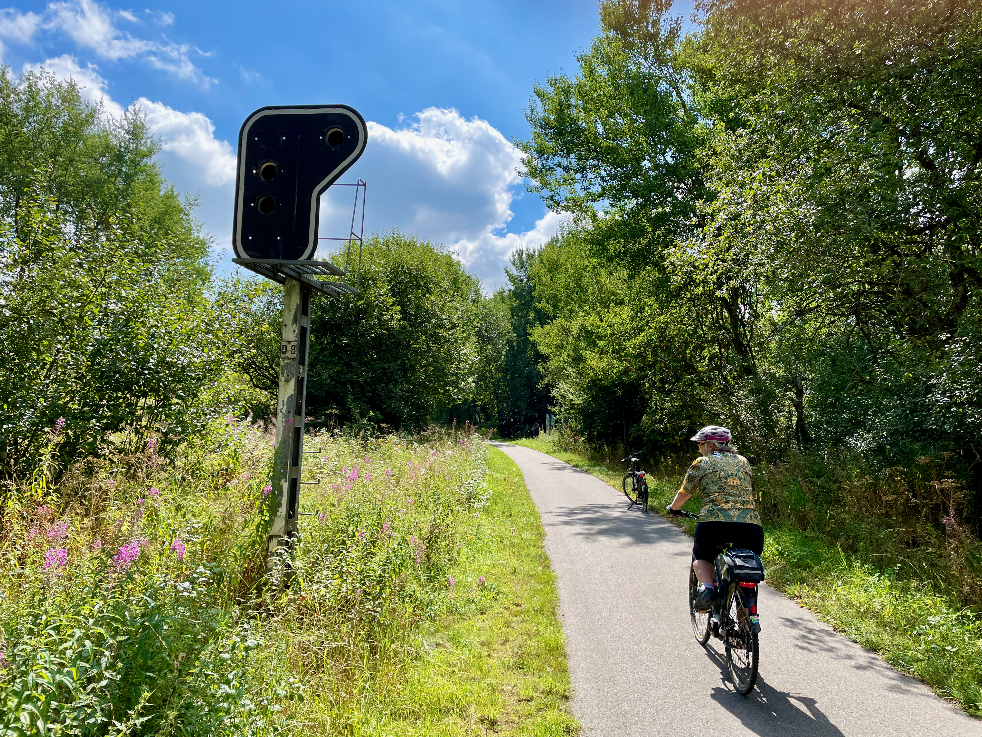
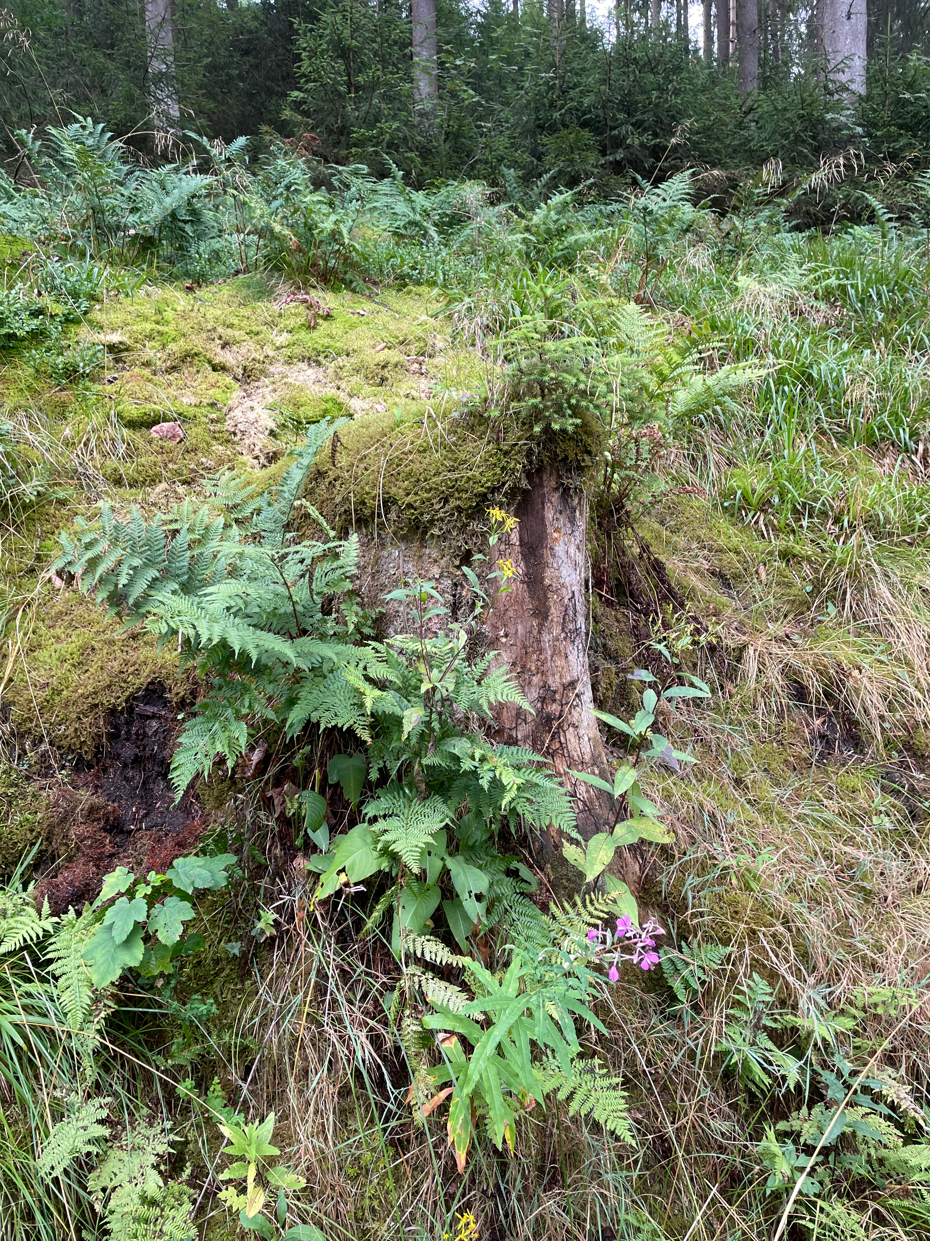
On the German Belgian border, where Heleen and I spent three wonderful days of cycling, there are similar, though not as complicated, borderlines. I have previously written about the delightful Vennbahn cycle route and these enclaves, so apologies for the repeat, but it’s such a delightful cycling area, please bear with me.
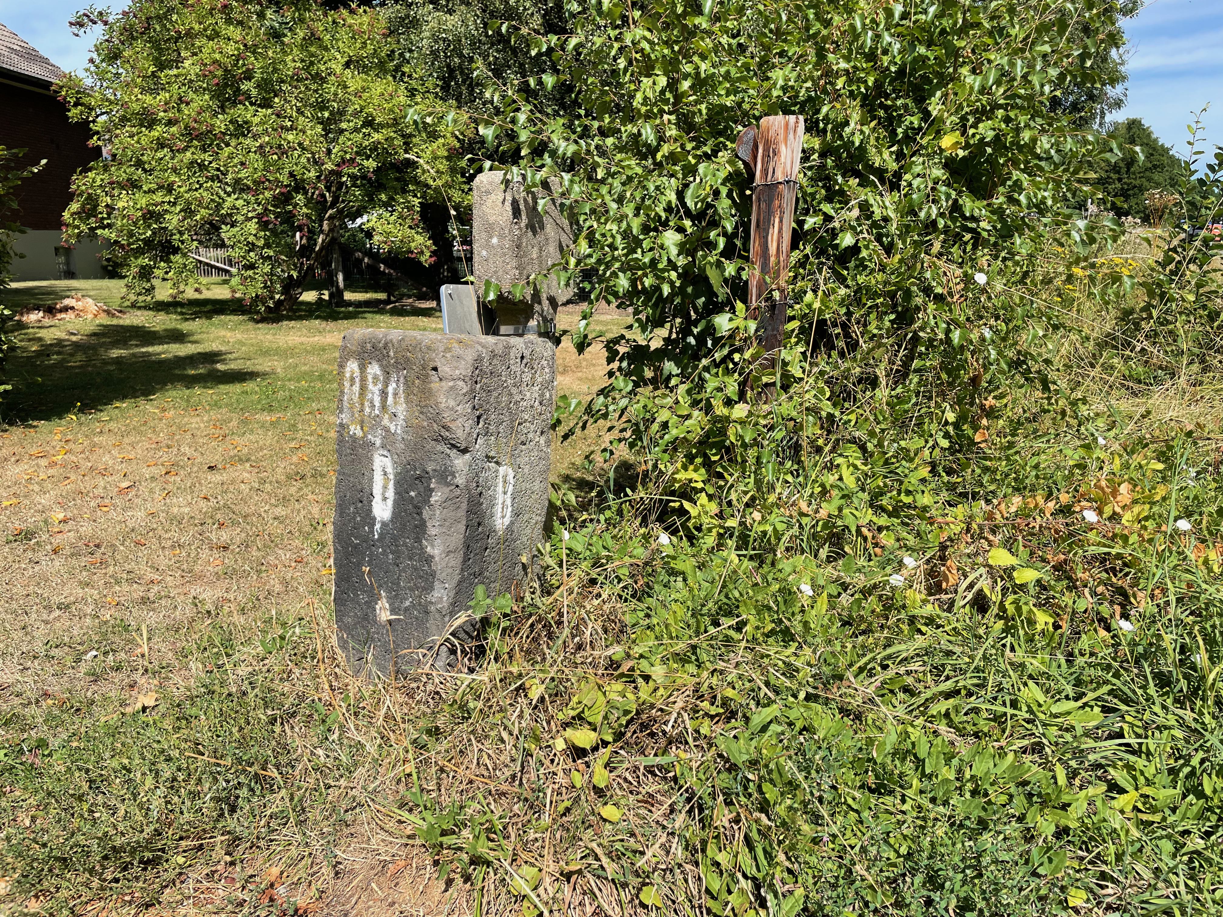
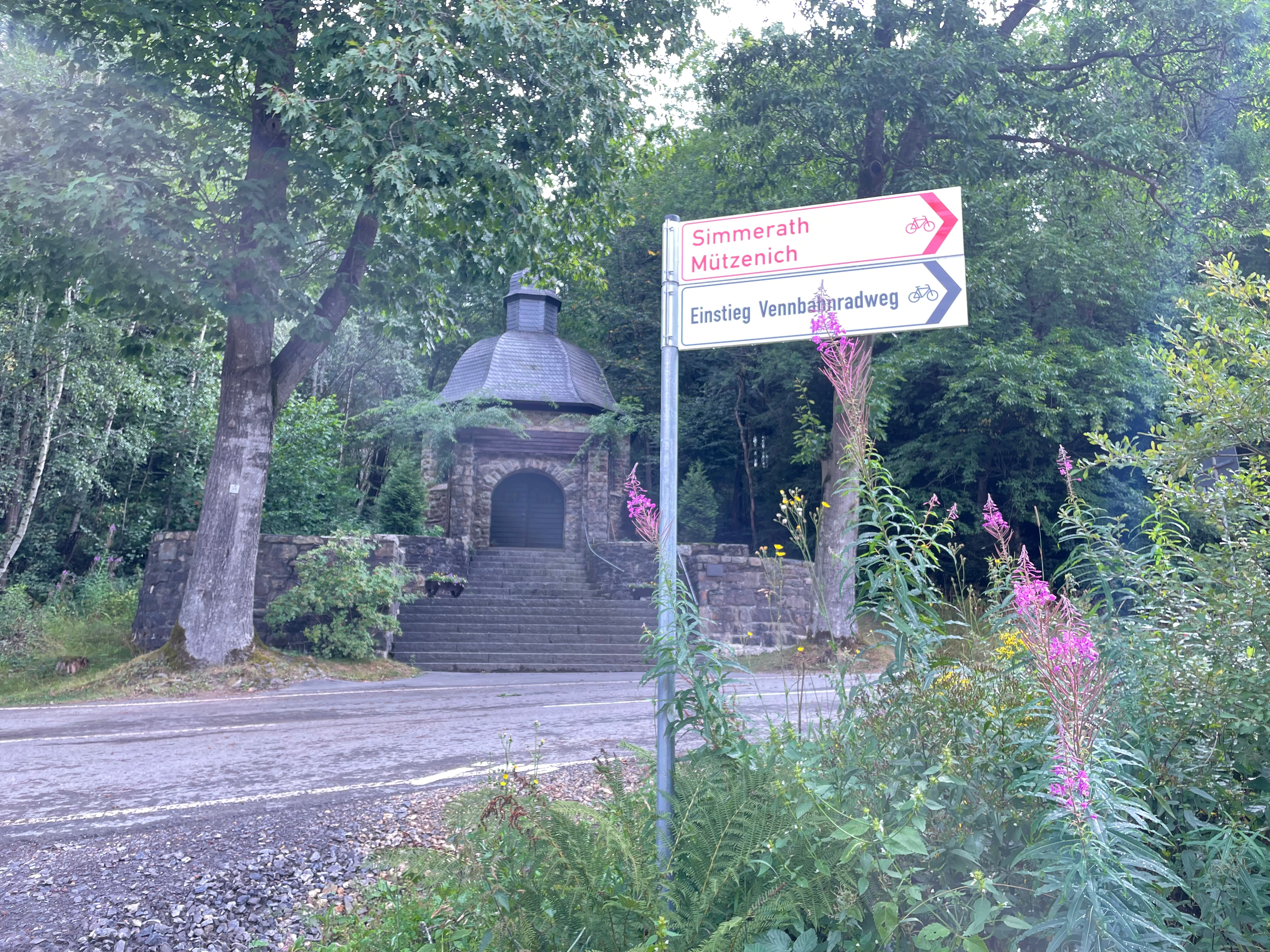
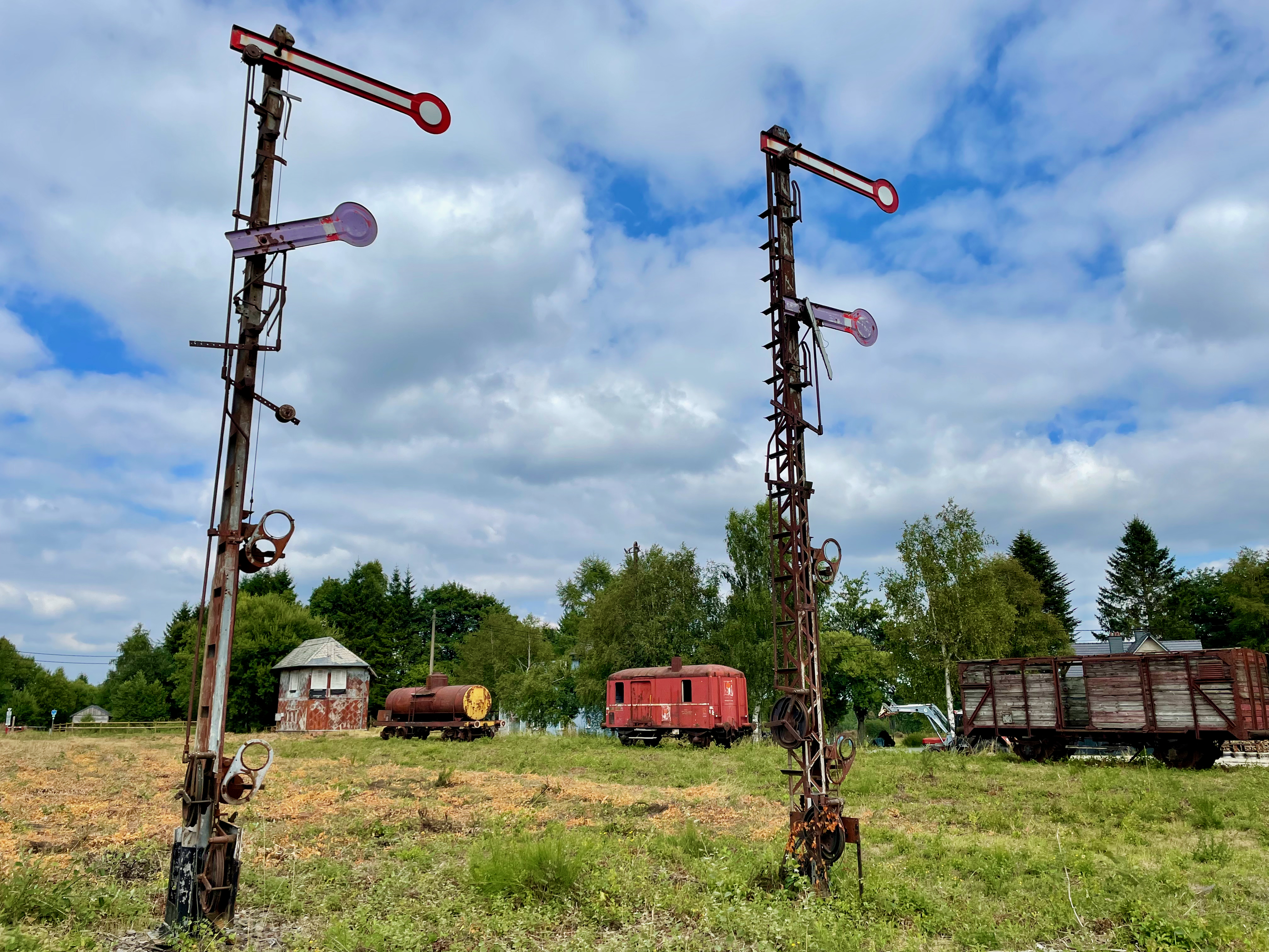
The Vennbahn or Venn Railway route has been Belgian territory since 1919, under the Versailles Treaty. It was originally built by the Prussian Government to primarily transport coal and iron, roughly between Aachen and the north of Luxembourg. When the Treaty became permanent in 1922, it meant that five enclaves of German territory (originally six) were formed, with the ‘bahn’ (railway track) a thin line of just a few meters of Belgium with Germany on both sides. The smallest German exclave, Rückschlag, consists of a house and a garden, some 155m x 100m according to my rough Google Earth measurements. I think I love cycling the Vennnahn cycle route for the feel and history of it because of the stunning railway remnants still visible; from old station platforms, railway signal posts and stop lights to the old station buildings. Maybe I love it for our daily stop at Kalterherberg station’s Waffelhaus for a cappuccino and sometimes a Belgian waffle, which really is so much better than any other waffle in the world; except maybe the Scottburgh Wimpy in the early 80’s?
A practical benefit of the open borders nowadays – on Sunday we stopped in Roetgen at a small supermarket to by an onion and iced coffees. The ‘left’ side of the road was in Belgium, where shops are open on Sundays, while across the road on the ‘right’ side, the shops were closed, because in Germany, the shops are closed on Sundays. We had onion on our burgers that evening, and ‘woema’ in our tanks for the Hautes Fagnes climbs ahead.
The area of Belgium is known as the Hohes Fenn, or Higland Moorland. The highland moor, which acts as a natural water reservoir, is the source of half a dozen rivers, including the Rur, Olef, Warche, Schwalm and Our.
The area where we cycled our 170km falls lock stock and barrel in the so-called Battle of the Bulge. The terrain is not all friendly and I indeed did battle with my bulge as well, but then decided I’ll only lose it if I stop those beer and waffle stops! Why would I cycle then?
The Battle of the Bulge was sort of Hitler’s last serious offense to try and prevent Antwerp as harbour to the Allies, before he hit the road, blew up the Bridge at Remagen as part of his retreat and took refuge in a bunker in Berlin for a while (not historically accurate, but you get my drift). However, it wasn’t all plain sailing for the American forces in this mountainous area. ‘The Hürtgen Forest occupies a rugged area between the Rur River and Aachen. This Rur is not the same river as the other Ruhr. The other Ruhr River has a ‘h’ in it, and is the water vein of that German industrial area which we all learned about in standard 4 geography. But this Rur is actually the same river as the Dutch Roer, and which flows into the Maas River at the stunning town of Roermond. In the autumn and early winter of 1944, the weather was cold, wet, and cloudy, and often prevented air support. Apart from the poor weather, the dense forest and rough terrain also prevented proper use of Allied air superiority, which had great difficulties in spotting any targets. The dense conifer forest is broken by few roads, tracks, and firebreaks; vehicular movement is restricted. Conditions on the ground became a muddy morass, further impeding vehicular traffic, especially heavy vehicles such as tanks’ (Wikipedia)
Its in similar terrain, bordering the Hürtgen forest in the Parc Naturel Hautes Fagnes or Hohes Venn where I battled my bulge, but on impeccable infrastructure. It remains, for me as a South African, incredible to be in fairly remote and secluded parts of these European forests, just to see a young lady strolling her Sunday stroll alone, and on two-meter-wide tarmac cycle roads for many kilometres, nogal.
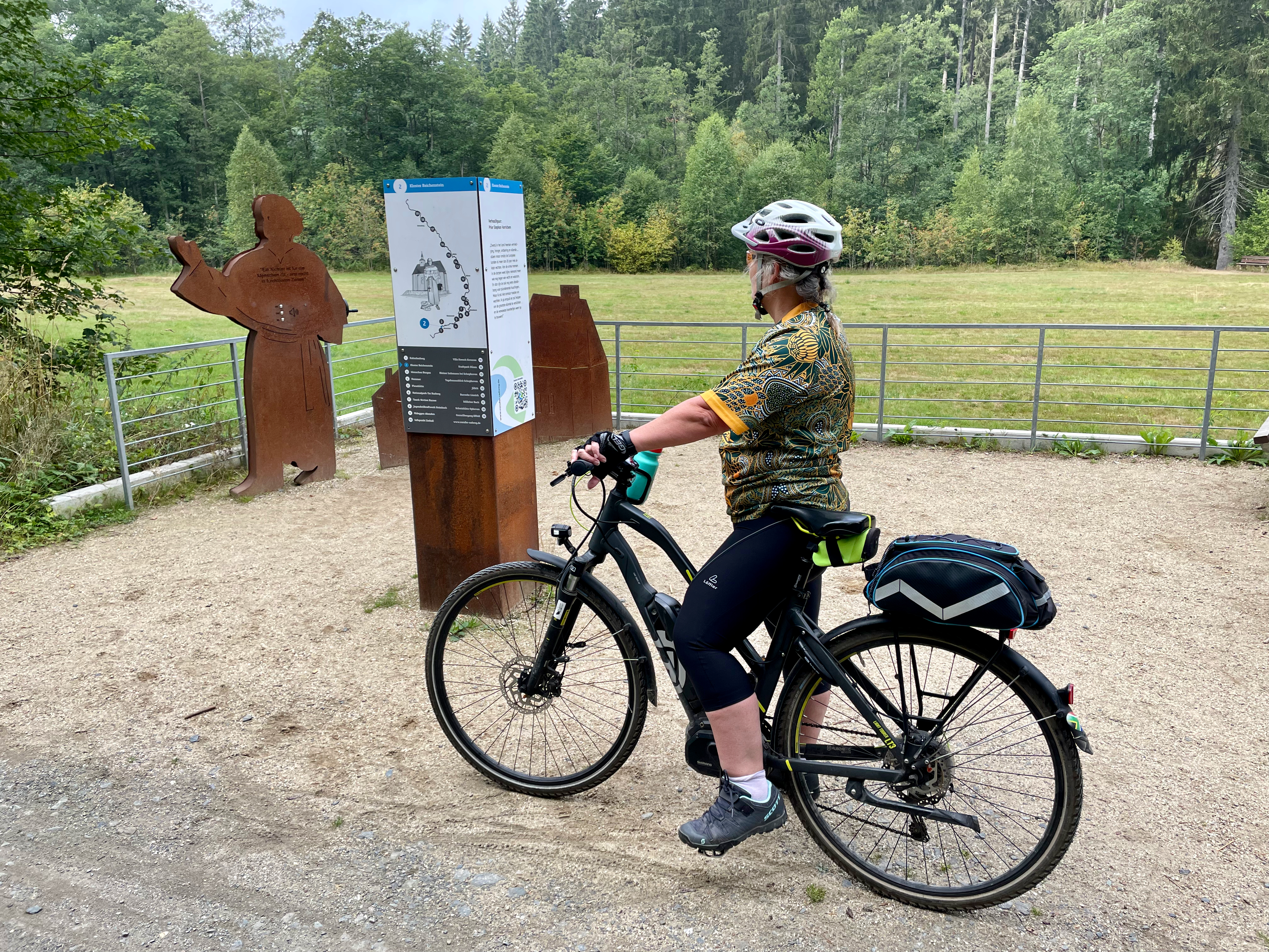
In the hilly forest of our daily start, is the interesting Kloster Reichenstein, which is currently being restored and where monks will soon again reside. In 1639, in the middle of the 30 year war, Stepfan Horrichem was put in charge of the Reichenstein Monastery as prior. Horrichem dedicated himself with full commitment to the consolation and assistance of the suffering population. Sometimes disguised as a farmer, he went from farm to farm and village to village to protect himself from infringement. In doing so, he earned respect, prestige and even admiration from the needy population. Next to the forest road, is a remembrance plague to Prior Horrichem, which unfortunately reminds us of the many many conflicts of Europe, as we actually see in the Ukraine at the moment.
You don’t have to be a cyclist, nor a camper, to visit and explore and enjoy this amazing part of Germany and Belgium, but to spend time in some of these slightly more remote nature-based camp sites in Europe, is highly recommended. The beautiful clean rivers, lush forests and green farmland hills all convert into real and peaceful scenic beauty.
I did find it rather funny. I know as a South African in Germany I don’t have a full understanding of history, geology, culture, past conflict, and context, but as we drove into Schleswig-Holstein, the Bundesland signage next to the road seemed a little near sighted, pun intended. ‘Schleswig-Holstein – der echte norden’ it said. Garmin profusely disagreed with a thick pink highlighted line and distance to destination clearly stating I had at least 2830km further to go to my ‘echte norden’ destination; The Nordkapp in Norway. I was wise enough not to be disappointed that I have ‘reached my destination’, and that I’ll have to stop enjoying a road-trip in my brand new LenieBus.
In German they refer to it as a ‘Kastenwagen’. In English we can therefor probably call it a Box Van, or maybe a Box Wagon, Panel Van, or Box Truck. If this was the 70s, maybe Passion Wagon or something similar that rhymes with truck. Whatever it’s called, it’s a midsized RV (Recreational Vehicle/motorhome) which puts us straight into the popular culture of van-life. LenieBus is our most recent travel equipment upgrade.
Heleen and I started our camping life and trips with borrowed tents, cooler boxes, sometimes Ventertjies (South African brand trailers), and flat cars such as VW Golf, VW Jetta or similar. It was fun and simple and allowed us to see many places. However, in South Africa, there are so much more to see and experience if you have off-road and dirt road capability, and thus we upgraded in 1998 to a VW Syncro Bus, but still sleeping in pitched tents and on the floor using blow-up mattresses. By then, we have become a family of four and in 2003 we upgraded to 4×4 ‘bakkies’ (pick-up trucks) when I bought my Echo 3 Off-road trailer with rooftop tent and my first Ford Ranger bakkie. We were kitted out and conquered every inch of dirt road, from ‘Kaap’ to Kalahari, Kruger to Molopo, Mapungubwe to Keimouth and ventured into the fantastic neighbouring countries like Swaziland, Botswana and Namibia.
We now live in Germany, and camping and road-tripping is slightly different than in the ‘platteland’ (rural) areas of South Africa. For starters, you really must go far and wide, and with a pinch of luck, to find a dirt road. Off the beaten tracks are however plentiful and within mainland Europe you can cover decent distance when you’re in the mood.
I was in the mood.
‘Let’s head north’ said Heleen.
‘Okay, but let’s go all the way north’, I replied.
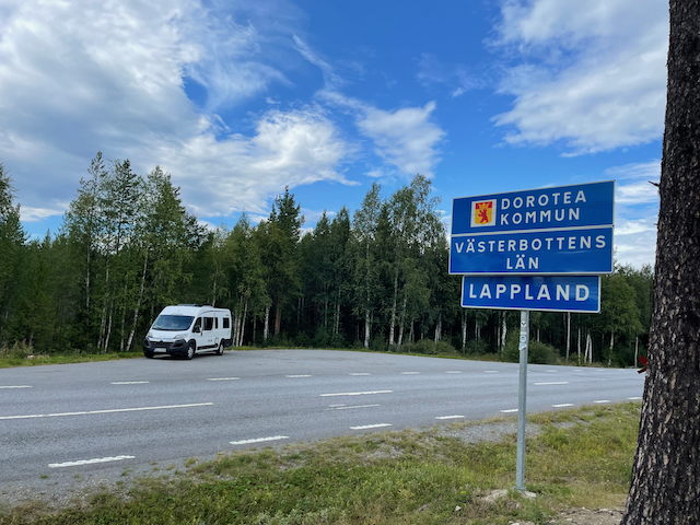
Our great Nordkapp road-trip was now reality. Nordkapp is Europe’s most northern point. After all kinds of delays with the delivery of LenieBus, we eventually received her keys and the go-ahead that she is now ours from Herr Dahlem at 15:00 on 2 August. We loaded stuff for a three-week trip and by about 21:00 we hit the road. That night we had our first ‘vanlife’ experience of sleeping in the parking area of Rastplatz Stettin, 181km from home on the A1 heading north, en-route to way beyond ‘der echte Norden’.
Allemannsretten (meaning “everyman’s right”) is a law that allows everyone to roam free on uncultivated land in Norway. … In practical sense this means that you are free to hike, camp and enjoy the fresh air in forests, mountains, and coastal areas, which make up most of the Norwegian nature, and for free nogal. This is what LenieBus enables us to do, and we were going to exploit this fully. Cara took it on herself to be the finder of great nature and secluded camping spots using mobile apps such as Park4night and Caravanya and after a stunning day of driving 830km in Germany, through Denmark and over and under the sea between Copenhagen and Malmo in Sweden we rolled into a beautiful nature spot called Rövarekulan for a well-deserved night’s sleep. One thing that I’ve learned in Europe, and on that day as well, is that the scariest people you meet while traveling are these young blonde police women manning the border entries in Europe. Four South Africans driving a van on SA passports in Scandinavia raised suspicions with this Swedish cop and it took decent scrutiny, computer checks and all for her to wave us away after about 20 minutes, looking a little jealous of the adventure that awaits us.
It was with a deepened sorrow that I drove north on day 3. I just received the news of the passing of Prof Johannes Hatting, a friend of mine from the ‘Kampvuur’ chat group, to which I belong. Johan was a professor in travel and he specialised in the Boer War history, mostly in and around Bloemfontein. The last message Johan posted in Kampvuur read ‘Ek stry hom al di (sic) afgelope week. Dis n fokop’ referring to his battle with Covid19. Johan passed away on 4 August, and is missed.
Planning trips generally are easy. You determine where you want to go, enter that into Google Maps or your Garmin and divide that reported distance by 100 to give you estimated driving time. Ouma Koekoe will differ with my calculation though, as I tend to wander even when driving, and she’ll instinctively know that my 8 hours will turn out to be 10 or more hours. However, Sweden and Norway taught me a valuable new reality. Even if it’s tarred and national roads, not all roads are equal. If you manage an average of 70km/h you can count yourself lucky. So my 3163km from home to Base Camp in Skarsvåg reported by Google to be 36 hours of driving does not equal my planned 4 days. It turned out to be day seven when we arrived at Skarsvåg which would be our Base Camp for the next three days. I should be fair to the roads however and confess that the slow drive has a lot to do with the immaculate scenery, a hotdog or two or six, the euphoria of the entire trip, the constant stop for photos at spots such as entering the arctic circle, the first sight of a real fjord, reindeer, to celebrate the Springboks’ series win over the British and Irish Lions on the shores of the Barents Sea in Altaelva plus the constant search for moose, bears and even wolves. We all realised that the chances of seeing bears or wolves from the seat of your vehicle on a public road were very slim, but I really expected to see a few moose. The proof was clearly visible that they are there by the number of spotlights on all the local vehicles, even the sedans.
So far, we had 6 nights in LenieBus, with just the one night in a caravan park. The others were all wild camping, of which three were exquisite nature spots next to lakes or in woods. One was next to the road because I decided before the time, as a matter of trip principle, that I do not want to drive after sunset. Though LenieBus have seats for four adults, the extra two passengers, my adult children, had to pitch a tent every night. For them it probably was a bit of a schlep, but for Heleen and me, sitting on a camp chair with a beer watching them pitch their tent, it was no schlep at all. Camping was now really easy. As Johan Bakkes wrote in a review in a South African magazine, camping with a campervan remind you of a tortoise, ‘you’ve got your house on your back’. You just pick a spot, push a button to let the little step shift out, so that you don’t pull a hamstring when you reach for the fridge, and open two camping chairs and two beers. The children will bring their chairs when their tent is pitched.
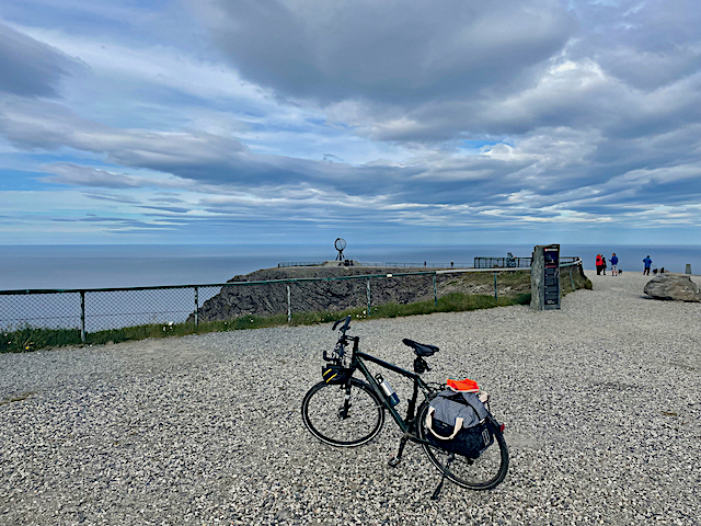
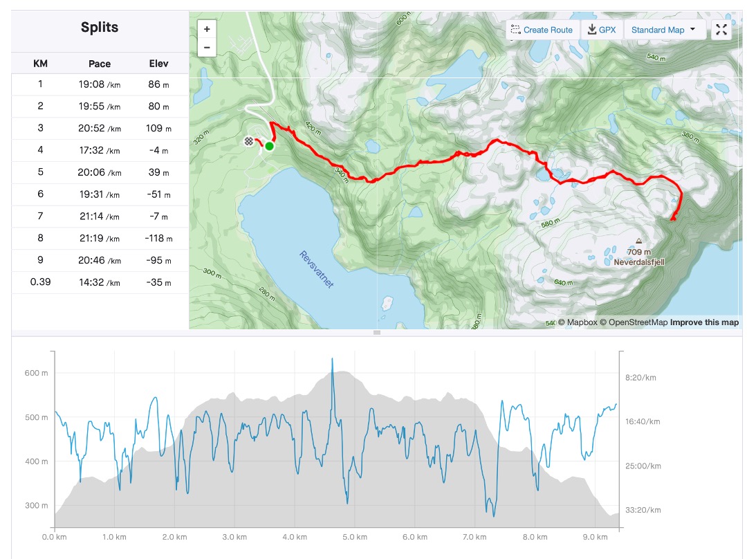
Day 1 at Base Camp camping site in Skarsvåg was supposed to be to do laundry and freshen up, but we had such a good camping spot and such good weather, that we sort of just sat around, enjoyed a lazy brunch, some short distance cycling and obviously threw some meat on the grill for a leisurely braai, while even having a swim in the arctic water of the Storvatnet lake on our doorstep. Day 2 was a little more serious, but this was why I brought the four bikes along. From Base Camp, it’s a further 16km to the actual Nordkapp, and this I wanted to do by bike – a nice leisurely 32km roundtrip with a total elevation gain of 721m. Nordkapp is situated at N71°21’10” and is the most northern point of Europe; thus for me it was a real bucket-list tick-off objective. To put this location into South African context; if I would go to 71°21’10” South, I would actually be on ‘dry ground’ in Antarctica, roughly 4070km south af Cape Agulhas! That’s a cool travel thought for me. (Africa’s most southern point at Cape Agulhas is at 34°49’59,6”).
“To move, to breathe, to fly, to float, to gain all while you give, to roam the roads of lands remote, to travel is to live.” (Hans Christian Andersen)
Turning south from Nordkapp I did some brief estimates and realised we had two weeks to get back home in Germany, but there were many things I wanted to see, places to stop at and photos to take. We could fortunately build in a few detours and there’s enough time to head south-west through most of Norway and visit places such as Lofoten, Bergen, the Trollstigen and the Preikestolen, to name just a few, … and which we did. Norway must be one of the most beautiful countries in the world. The scenic splendour is endless, the 1700 named fjords range from the massively large Sognefjord which stretches 204km inland to the narrowest Nærøyfjord which spans a mere 500m in width at some places. The European Road E39 is the main road leading south, but it is by no means a highway. Traveling at averages of about 60km per hour is common, and you should not be in a hurry when you decide to road-trip in Norway. Heading south we leisurely meandered and attempted wild camping as often as possible. It’s hard to highlight the best overnight stops but worth specific mention are the nights
next to Fjord Kjaeken, facing west and just enjoying the sunset at about 23:00, while a bottle of Roodeberg, two otters and some dolphins add to the tranquility, plus here I found some dirt road,
the night at Vevang on the Atlanterhavsveien or Atlantic Ocean Road with those magnificent sea crossing bridges,
the night next to a remote road on the banks of Dam Sunnfjord and swimming in the icy waters for the brave amongst them (or stupid?),
and the camping in basic campsites such as
Solnaset Gard (farm), and
The Preikestolen campsite where the owner who frequently travels to South Africa and the Kruger National Park, actually installed braais similar to those well-known ones the South African Parksboard have in all their camps.
Lofoten is an archipelago located at the northwest of Norway, where the dramatic mountain- and sea views are never ending, and where the entire peninsula is lined with picturesque fishing villages. Probably the most famous and definitely worth the visit is the town Henningsvær, with its soccerfield virtually build in the sea on a small peninsula. A fascinating learning experience, and excellent thick vegetable and reindeer soup, is available at the Lofotr Viking musem, with its restored longhouse and Viking boats. This house belonged to the powerful Chieftain of Borg and dates from the years 700 AD. I am not sure what Borg’s relationship was with Ragnar Lothbrok and his sons was, but Borg himself had quite a dwelling of note.
When traveling in Norway, you are going to use ferries and toll-roads, and its completely justified when you consider the infrastructure of these tunnels and ferries and time saved by using them. With some routes it simply is not wortwhile to search for alternative routes, and though some bloggers and travel writers criticise the cost, in the end I didn’t think it was overly pricey. On most of the toll-roads and ferries, you simply use them, and get billed later. Photos are taken of your car registration, and the bill is then posted or emailed to you. Its wise to preregister on the website of the Toll Collection company Epass24 and just let the transactions get paid automatically from your preregistered credit card, at a discounted tariff because you’ve registered. Below is a summary of my toll and ferry costs.
One or two toll gates were paid in cash though, including a real expensive €125 for the road crossing between Denmark and Sweden, as well as the ferry crossing between Norway and Denmark (Kristiansand to Hirtshals).
Part of travel experience is obviously to enjoy local cuisine and learn a little about the tastes, flavours and sources of sauces of the country. Since we were on a self-catering self-drive adventure, I can confirm that Cara makes a mean spaghetti bolognaise, Heleen all kinds of traditional ‘padkos’, Stean a mean ‘braaibroodjie’ and I can still ‘braai’. We did now-and-then eat out and in Norway you have plenty of excellent fish, reindeer meatballs with sauce (called kjøttkaker) and potato dumplings (called raspeball), stew (called lapskaus), and lingonberry cream (called trollkrem) for dessert as local dishes. However, by far the biggest traditional dish, from our personal experience are hotdogs. To Norwegians ‘hotdog’, is like ‘braai’ to South Africans; the go-to solution to everything. Hotdog is not really a verb, but in Norway it is. We hotdogged a lot. It’s not a massive exotic hotdog at all. As a matter of fact, its smallish, with the bun way too small for the sausage, but its tasty, with a choice of sauces and I think the big selling point is the bun is soft, not one of those palate breaking baguettes that frequents most of Europe’s bakeries. Don’t get me wrong, there is nothing wrong with a fresh baguette, but if you have them too frequently, you kind of end up looking like Dracula with the blood from your cut palate streaming from your mouth; and it hurts! These Norwegian hotdog buns are like freshly washed thick towels emerging from the tumble dryer, compared to wind dried towels washed with Sunlight soap in a river. To elaborate more on this, should rather be left to the professionals, and thus I refer you, to https://www.scandikitchen.co.uk/hotdog-scandinavian-way/ though I can affirm for the Norwegian hotdog as being the go-to snack, every time you stop for fuel, coffee, groceries, or, … er, well, when you stop. Its dirt cheap, delicious, and available everywhere.
Atlanterhavsveien or The Atlantic Ocean route is a roughly 9km road between the towns Kårvåg and Vevang. The road runs across an archipelago of partially inhabited islands and skerries and consists of eight bridges, four resting places and plenty of dramatic scenery. We traversed the road on a beautiful summer’s day with a calm sea and absolute exquisite scenes of natural beauty around us. We stopped, probably had a hotdog, and drove parts of the route more than once just to provide the opportunity to take it all in, and to let the drone do it’s thing.
When you think of the tourist attractions of a nature paradise such as Norway, there obviously are a few that form the basis of your trip planning. Nordkapp, a couple of fjords, Atlanterhavsveien, Trollstigen and the Preikestolen were sort of my reference via points to plan my route on. It doesn’t mean that’s it, as everything in-between is just pure splendour (remember that I’m talking 8327km here). However, you should at least plan for these four, and the fortunate thing is that you will see a couple of fjords in the process.
Serenity
After a stunning drive from Lofoten, which included the Atlanterhavnveien, we found a secluded wildcamp site next to a small road and sat down to reminisce about everything we have seen, and still are experiencing.
“I have found out that there ain’t no surer way to find out whether you like the people or hate them than to travel with them.”(Mark Twain)
I love them.
Time was starting to become an issue, traveling was slow, and the road home still far. But I had two more sights to see, and I was adamant.
The Trollstigen is a famous serpentine mountain road and major tourist attraction due to its steep incline of 10% and eleven hairpin bends up a steep mountainside. It is the ascent (or descent) at the end of the beautiful Isterdalen (valley) which, while driving the pass, provides excellent views of the valley as well as the Stigfossen waterfall. Trollstigen means the troll path or troll trail. I’m not sure what Norway’s big thing with trolls are?
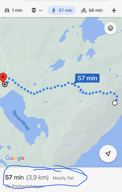
At the foot of the trail to the Preikestolen (Pulpit rock) is the Preikestolen camping ground. We arrived in the afternoon, and were slightly under time pressure, since we wanted to visit the actual pulpit rock that same day, so that we could travel home the next day. We (I mean the children) pitched their tent, and we put on our walking shoes. I consulted Google Maps and planning fell into place – 57min walk, Google said, 3.9km Google said, and ‘mostly flat’ Google said. Google lied! However, after a 9.6km roundtrip (4.8km one way) and a climb of 605m and a 3:06:05 moving time (3:52:57 elapsed time), I opened a beer very very satisfied back at the campsite. We were tired, but happy. The scenery is out of this world, the last tick-box of our Norway trip was ticked off and we sat around a campfire build on a Kruger National Park lookalike ‘braaier’. The owner of the campsite is a fond traveller to South Africa, and he particularly loves the Kruger National Park. So much so, that he installed similar braaiers in he’s Norway camping ground.
I was happy and I felt extremely blessed. Except for two more days of driving, this was the end of an absolute epic and wonderful family holiday.
Now, as I write this trip report in my warm lounge at home on this freezing December morning, I cannot wait to turn LenieBus’s nose in some new direction and get going again. I must remember to order a case Springfield The work of Time.
It is one of those songs, which I cannot read the words without singing the tune. I still have the record (LP) ‘Come along and sing along’ with Charles Berman and company
This LP gave me hours of pleasure growing up
which I’ve listened uncountable times as a kid growing up in Yellowwood Park, Durban. In my head this Em’rald Isle they mentioned was some exotic sunny island with coconut palms, white sandy beaches and hours of leisure in the sun. I simply had to one day visit it! It was with a big ‘Ahh, they talk about Ireland’ that I later learned what the Em’rald Island actually was, but it never tempered my curiosity to one-day travel over this island.
Nowadays the musical reference to Ireland is probably more Ed’s Galway Girl, and that too is a great song, rather than Kelly.
If I still had a slight expectation of sunny beaches and leisurely hours enjoying those sunny beaches in my head in anticipation of our 10 day Ireland trip, I was rudely jerked into reality when we received the message from Ryan Air about 36 hours before our flight informing us our flight was cancelled! Not delayed, sommer completely cancelled, gone, finish ‘en klaar’. Europe was caught in a week of serious snow and bad weather and Dublin airport was closed for a few days. After frantically phoning around and surfing around (the web kind, not the anticipated sunny waves kind of surfing), Cara was able to get us a 22:00 flight, for the Sunday evening! We were supposed to fly Thursday but had to wait until Sunday night. Before you think of my Ugly Story post and that infamous Lufthansa flight LH572, this was different and we accepted it as such, while keeping our eyes peeled to weather forecasts and news bulletins of the European weather scene. Oh, by the way, after 22 months, Lufthansa refunded us a few euros per ticket, of which the lawyers took nearly half.
We landed in Dublin at 23:30 Sunday night, picked up our rental car, grabbed a serious coffee or two or six, and headed into the snowy, misty darkness of the M4 and the 215km I had to drive to get to our Galway accommodation.
It was a good call to drive through to Galway that night, because we woke the next morning at our destination, with a view across the bay, and a little grocery store stocking real bacon, eggs and cheddar among a few other necessities just around the corner. English breakfasts instead of continental in itself is sufficient reason for visiting Ireland.
Trickling waterfall in country side using iPhone and long exposure
Can you imagine having been intimidated, interrogated and abused in the ‘old days’ of madness, and then many years later, after walls came tumbling down, you bump into your bully in a grocery store?
That’s the story our hotelier in the amazing city Schwerin shared with us at breakfast. His wife was clearly still shaken up by this experience, but that is so much reality in many parts of Germany, or the larger previously communist Eastern Europe.
Heleen and I decided to explore the far northeast of Germany for a week and to see what surprise destinations, in both sights and history we could find. And oh boy, did I enjoy it.
Schwerin is the capital city of German state of Mecklenburg-Vorpommern and is particularly known for its breath-taking palace. The palace is currently the office of the state government and is situated on the lake island just out of town. It was February and as can be imagined, the weather was not ‘African friendly’ weather, but we were brave, tightened the scarves and strolled the beautiful island, amazed at the majestic palace before we sniffed out a delicious traditional German potato-, leek- and ‘wurst’ soup with bread and a glass of nearly acceptable quality wine in the well preserved ‘altstadt’.
Schwerin Palace
I attempt to also appreciate the extremely interesting other historic periods strolling the town and sights, but the Stasi- and the cold war period is constantly in my head. So much more after having a very absorbing conversation with our hotelier and being informed that the big empty building 200m from the hotel is actually the old Stasi Head Office, where his wife had her nightmare experience many years before. It was actually right there on our doorstep and one of many places where so many serious atrocities happened resulting in numerous innocent people’s life so dramatically influenced by the communist and socialist bully methods. This incident, of the hotelier wife and her face-to-face years later with her interrogator immediately reminded me of Anna Fulder’s book, Stasiland, and that particular comment Miriam made to Anna when she said, ‘And I think about those Stasi men. They would never in their lives have imagined that they would seize to exist and that their offices would become a museum. A museum!’ She then further says ‘I like to drive up to the Runde Ecke and park right outside. I just sit there in the car and I feel …. triumph! Miriam makes a gesture which starts as a wave, and becomes a guillotine. ‘You lot are gone’.
‘You lot are gone!’
And that’s the lesson. Nothing lasts. Not Eric Mielke and his Stasi nor the Gadaffi’s, Sadam Hussains, or Robert/Grace Mugabes and their cronies.
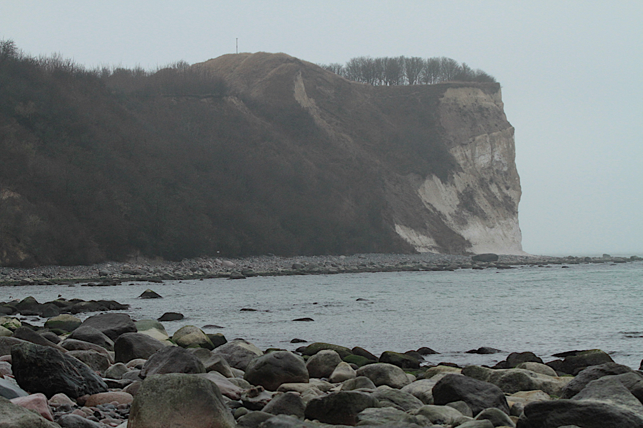
I like driving around in these remoter parts of the over developed Germany. Here you still get a feeling that its slightly remote and rural – definitely not Karoo remote – but at least slightly less built up than Northrhein Westfalen, where we live. Once you’ve succeeded in shifting the Stasi history out of your head for a while, you realise how scenically beautiful this part of Germany is. Schwerin sits next to a beautiful lake, the Schwerin See, (yes, the Europeans call a lake a sea and the sea a ‘meer’, but then again, Obelix did repeatedly state that they are slightly crazy!). This northern coast provides some extra scenic splendour including the white cliffs at Putgarten on the island Rügen. It’s a worthwhile destination to go hiking, even in bad weather. Bad weather here has the knack to shut you off from the rest of the world. Its just you, the grey of the air and sea and the beautiful green of the coast, with a bleak hint of the whitish cliffs in the distance. And just before you freeze, you end your hike back in town in a small pub-like restaurant with thick vegetable soup and fresh bread. Winter here is grey, but it’s a grey that has its own peculiar excellence.
Further east and on the border with Poland is the holiday town, Heringsdorf, on the Usedom Island. The area is known as Kaiserbad, as it was the favourite spa destination of the German Emperors in days gone by due its its clean beaches and the long sandy stretch. It actually is the longest sand beach in Europe, being 40km in total distance. Heringsorf was our base for a few days from where we visited the astonishing Świnoujście (Swinemünde) which has a harbour in the river mouth of the Swine river. This was a major German naval base during WW2 as well as the Cold War period. On the beaches of Heringsdorf the military lookout towers are still plentiful. The irony about these is that they were mostly used, similar to the Berlin Wall, to keep the ‘free’ people of the German ‘Democratic’ Republic from defecting, and not so much as defending against external threats entering!
Keeping your people from defecting, not enemies from entering
Some 40km to the west of Heringsdorf we strolled in fascination through the museum in Peenemünde. Here an Army Research Centre was founded in 1937. Many serious weapons, including guided missile and rocket weapons were tested and designed here using the nearby concentration camp inmates as forced labour – forced to build weapons they knew would destroy their homeland and massacre their own people. During the Cold War Soviet days it was rumoured that the Soviets revived Peenemünde for their space program.
Heading back home to Bad Honnef, I decided to drive via the historic towns of (Lutherstad) Wittenberg and Erfurt to spend a few hours in the footsteps of Martin Luther, the father of the German Protestant movement. It is 500 years ago (October) since he nailed his 95 theses to the door of the church in Wittenberg and certainly was a door I needed to see. The Luther church was inspiring to see, but as a town the old part of Erfurt was something extraordinary. It was here, in Erfurt where Martin Luther was ordained in the Cathedral of St Mary, which dates back to the 8th century and where he also delivered many of his sermons. Still intact in Erfurt is the Krämerbrucke (or merchant bridge) and its medieval houses spanning the Gera River. The original bridge was an important part of the trade and pilgrims routes connecting Rome with the Baltic Sea. It was originally a wooden bridge but was destroyed many times by fire. The current stone bridge, which is lined on both sides with half-timbered houses, was completed in 1472.
En route back home to ‘West Germany’, we stopped a last stop to sort of exit ‘Eastern Germany’ officially at a fantastically interesting museum called Point Alpha. Its one of many ‘Grenz’ museums where the ‘iron curtain’ became real. Point Alpha specifically was the border between the towns Rasdorf in the west and Geisa in the east. It has an excellent museum depicting the inner German border as well as some well-preserved samples of various stages of the original border.
After a thoroughly enjoyable week back in history and into a cold grey era, I must admit that there was a feeling of relief that we were heading west, and that it was into an era well beyond 9 November 1989, the day when such important walls came tumbling down. Walls aren’t the answer.
‘On day four, it was time to move on. Francois and Talitha said their goodbyes and headed back to Wildernis, while we headed north-west, towards Mata Mata and its border post. We still had 10 days ahead to explore the vast distances and rugged beauty of the Namib and Etosha. Distance for today was 774km of dirt road; pure ‘lekkerte!’’
Mata Mata is one of the three conventional camps in the Kgalagadi and lies on the eastern border of Namibia with the convenience of a border post. One can enter and exit Namibia at this post if you stay in the Kgalagadi Transfrontier Park for two nights, preventing the park becoming a transit route, which is obviously a good rule. Namibia has vast distances and travellers more often than not underestimate the travel distances and times. I too made that mistake. Not so much in my planning, but more so in my execution. Enjoying the goodbyes with Francois and Talitha, the showers in Twee Rivieren and the game drive from Twee Rivieren to Mata Mata too much, meant that we exited South Africa about three hours later than initially planned. We still had 570km to cover from Mata Mata to Sesriem, and it was already after lunchtime. Of the 570km 90% was dirt roads, which translates to at least 8 hours of driving. Its normally not a problem, but this being wild country with plenty of wild animals, its not wise to travel after sunset. That clichéd quote ‘its better to travel hopeful than to arrive’ really rang true that evening, with frequent encounters with oryx, zebra, kudu and other large animals roaming the roads in the dark. Fortunately, we travelled well and arrived safely at Sossus Oasis Camp Site, Sesriem.
Namibia must be one of the best-kept secrets and I actually don’t want to promote it too much through my blog, as I’m afraid of more people traveling there and spoiling it for us selfish ones. It is pristine, wild, mostly dry, tranquil but rough and expansive. And why I have a very selfish stance on trying my little best to keep it that way is because people spoil things. Sitting and enjoying our campfire late afternoon the next day, sipping a Pinotage from Tulbach and not speaking much, the serenity was abruptly ended by an Englishman and a German entering a particularly abusive shout-fest over their camping spot and access to the electricity. Right there and then, Europe spoiled a perfect African setting for the better part of an hour. But the rough beauty of the place convinced me to ignore them and enjoy the splendour of God’s creation.
Though Lufthansa may be at risk, due to their lack of customer service (see my previous post Flight LH572 July 22, 2016 : An ugly story), we eventually did arrive in South Africa, and we did enjoy all the promised ‘braais’, ‘kuiers’ and catch-up with all and sundry; exactly the things Expats do when returning home for a visit. It was fortunately not ‘allesverloren’!
A truly special place is the Kgalagadi. Its one of those places which I truly wish I could show off to everybody I meet in Europe. It’s a pristine wilderness in the dry western parts of South Africa and Botswana as God intended and where wild beasts roam freely. The Kgalagadi Transfrontier Park is one of the most pristine conservation areas on earth, and that was the first destination of our two week Kgalagadi and Namibian safari.
Special places require special equipment. Though the Kgalagadi Transfrontier Park has normal dirt roads and its theoretically accessible with a sedan, its not advisable. Even when the roads are well maintained, you are still confronted with high sand walls next to most of the roads, which means while we are scanning the wide plains for Oryx, Springbuck, Lions et al from the raised elevation of the Land Rover, the sedan driver scans a meter high sand wall for ants, grouse and desert rats! To fully enjoy the Kgalagadi, one needs to have a bakkie, kombi or similar high, big tyres vehicle.